Syria civil war
| Syrian Civil War | |||||||||||
|---|---|---|---|---|---|---|---|---|---|---|---|
| Part of the Arab Spring, the Arab Winter, the spillover of the Iraqi Civil War, Iran–Saudi Arabia proxy conflict | |||||||||||
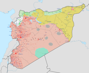
 Current military situation: Red: Syrian Government, Green: Syrian Opposition, Yellow: Rojava (SDF), Grey: Islamic State of Iraq and the Levant, White: Tahrir al-Sham (formerly known as the al-Nusra Front) For a more detailed map, see Cities and towns during the Syrian Civil War. The map above was last updated on 27 February 2017. |
|||||||||||
|
|||||||||||
| Main belligerents | |||||||||||
|
Allied groups
Support:
|
Support:
Support:
|
(from 2012) Support:
|
|||||||||
| Commanders and leaders | |||||||||||
KIA:
|
KIA:
...
| ||||||||||
