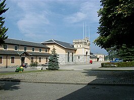
Lancy
| Lancy | ||
|---|---|---|
 |
||
|
||
| Coordinates: 46°11′N 06°08′E / 46.183°N 6.133°ECoordinates: 46°11′N 06°08′E / 46.183°N 6.133°E | ||
| Country | Switzerland | |
| Canton | Geneva | |
| District | n.a. | |
| Government | ||
| • Mayor |
Maire Pascal Chobaz |
|
| Area | ||
| • Total | 4.77 km2 (1.84 sq mi) | |
| Elevation | 307 m (1,007 ft) | |
| Population (Dec 2015) | ||
| • Total | 31,359 | |
| • Density | 6,600/km2 (17,000/sq mi) | |
| Postal code | 1212, 1213, 1227 | |
| SFOS number | 6628 | |
| Surrounded by | Carouge, Geneva (Genève), Onex, Plan-les-Ouates, Vernier | |
| Website |
www SFSO statistics |
|
| Nationality | Amount | % total (population) |
|---|---|---|
|
|
3,074 | 10.5 |
|
|
1,363 | 4.6 |
|
|
1,034 | 3.5 |
|
|
1,031 | 3.5 |
|
|
350 | 1.1 |
|
|
214 | 0.7 |
|
|
213 | 0.7 |
|
|
205 | 0.7 |
|
|
161 | 0.5 |
|
|
161 | 0.5 |
|
|
135 | 0.5 |
|
|
117 | 0.4 |
|
|
109 | 0.4 |
|
|
102 | 0.3 |
|
|
97 | 0.3 |
|
|
91 | 0.3 |
|
|
80 | 0.3 |
|
|
78 | 0.3 |
|
|
73 | 0.2 |
|
|
71 | 0.2 |
Lancy is a municipality of the Canton of Geneva, Switzerland.
Lancy is first mentioned in 1097 as Lanciaco meaning "fearless".
Lancy has an area, as of 2009[update], of 4.77 square kilometers (1.84 sq mi). Of this area, 0.25 km2 (0.097 sq mi) or 5.2% is used for agricultural purposes, while 0.31 km2 (0.12 sq mi) or 6.5% is forested. Of the rest of the land, 4.26 km2 (1.64 sq mi) or 89.3% is settled (buildings or roads), 0.02 km2 (4.9 acres) or 0.4% is either rivers or lakes.
Of the built up area, industrial buildings made up 8.2% of the total area while housing and buildings made up 45.7% and transportation infrastructure made up 26.4%. Power and water infrastructure as well as other special developed areas made up 2.7% of the area while parks, green belts and sports fields made up 6.3%. Out of the forested land, 5.0% of the total land area is heavily forested and 1.5% is covered with orchards or small clusters of trees. Of the agricultural land, 3.4% is used for growing crops and 1.5% is pastures. All the water in the municipality is flowing water.
The municipality is located on the left bank of the Rhone river. It consists of the villages of Grand-Lancy and Petit-Lancy (which are separated from each other by the Aire valley) as well as the hamlets of Pesay, Saint-Georges, La Tour, La Vendée, Le Pont Rouge.
The municipality of Lancy consists of the sub-sections or villages of Les Grandes-Communes, Lancy - Saint-Georges, Petit-Lancy - Tivoli, Surville, La Praille - Pont-Rouge, La Praille - Marchandises, La Praille - Rte des Jeunes, La Praille - stade, Lancy - La Chapelle, Le Bachet, Les Palettes.
Lancy has a population (as of December 2015[update]) of 31,359. As of 2008[update], 35.0% of the population are resident foreign nationals. Over the years 1999–2009 the population changed at a rate of 12%. It changed at a rate of 6.2% due to migration and at a rate of 6.2% due to births and deaths.
Most of the population (as of 2000[update]) speaks French (20,422 or 79.5%), with Portuguese being second most common (1,031 or 4.0%) and Italian being third (1,029 or 4.0%). There are 883 people who speak German and 10 people who speak Romansh.
...
Wikipedia


