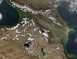
Armenian highlands
| Armenian Highlands | |
|
The Armenian Mountain Range near the Turkey-Iran border
|
|
| Country | Armenia Azerbaijan Georgia Iran Nagorno-Karabakh Republic Turkey |
|---|---|
| Region | West Asia |
| Highest point | Mount Ararat |
| - elevation | 5,137 m (16,854 ft) |
| - coordinates | 39°43′N 44°16′E / 39.717°N 44.267°E |
| Area | 400,000 km2 (154,441 sq mi) |
The Armenian Highlands (Armenian: Հայկական լեռնաշխարհ, Haykakan leṙnašxarh; also known as the Armenian Upland, Armenian plateau, Armenian tableland, or simply Armenia) is the central-most and highest of three land-locked plateaus that together form the northern sector of the Middle East. To its west is the Anatolian plateau which rises slowly from the lowland coast of the Aegean Sea and converges with the Armenian Highlands to the east of Cappadocia. To its southeast is the Iranian plateau, where the elevation drops rapidly by about 600 metres (2,000 ft) to 1,500 metres (5,000 ft) above sea level.The Caucasus extends to the northeast of the Armenian Highlands. To the southwest of the Armenian Highlands is Upper Mesopotamia.
During Antiquity, it was known as Armenia Major, a central region to the history of Armenians, and one of the four geo-political regions associated with Armenians, the other three being Armenia Minor, Cilicia and Commagene. During the Middle Ages, Turkmens settled in large numbers in the Armenian Highlands.
The region was historically mainly inhabited by Armenians, and minorities of Georgians and Assyrians. The Christian population of the Western half of the region was exterminated during the Armenian Genocide of 1915 and to a smaller scale the Assyrian Genocide.
...
Wikipedia


