Aral Sea
| Aral Sea Арал теңізі (Kazakh) Orol dengizi (Uzbek) Аральское море (Russian) |
|
|---|---|

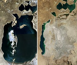
The Aral Sea in 1989 (left) and 2014 (right)
|
|
| Location |
Kazakhstan - Uzbekistan, Central Asia |
| Coordinates | 45°N 60°E / 45°N 60°ECoordinates: 45°N 60°E / 45°N 60°E |
| Type | endorheic, natural lake, reservoir (North) |
| Primary inflows | North: Syr Darya South: groundwater only (previously the Amu Darya) |
| Catchment area | 1,549,000 km2 (598,100 sq mi) |
| Basin countries | Kazakhstan, Kyrgyzstan, Tajikistan, Turkmenistan, Uzbekistan, Afghanistan, Pakistan |
| Surface area | 17,160 km2 (6,626 sq mi) (2004, four lakes) 28,687 km2 (11,076 sq mi) (1998, two lakes) 68,000 km2 (26,300 sq mi) (1960, one lake) North: 3,300 km2 (1,270 sq mi) (2008) South: 3,500 km2 (1,350 sq mi) (2005) |
| Average depth | North: 8.7 m (29 ft) (2014) South: 14–15 m (46–49 ft)(2005) |
| Max. depth | North: 42 m (138 ft) (2008) 30 m (98 ft) (2003) South: 37–40 m (121–131 ft) (2005) 102 m (335 ft) (1989) |
| Water volume | North: 27 km3 (6 cu mi) (2007) |
| Surface elevation | North: 42 m (138 ft) (2007) South: 29 m (95 ft) (2007) 53.4 m (175 ft) (1960) |
| Settlements | Aral, Kazakhstan and Mo‘ynoq, Uzbekistan |
The Aral Sea (Uzbek: Orol dengizi; Karakalpak: Aral ten'izi; Kazakh: Арал Теңізі Aral Teñizi; Turkmen: Aral deňzi; Russian: Ара́льское море, tr. Aral'skoye Morye; IPA: [ɐˈralʲskəjə ˈmorʲɪ]; Tajik: Баҳри Арал Bahri Aral; older Persian: دریاچه خوارزم Daryâche Khârazm; Mongolian: Арал тэнгис; Chinese: 咸海) was an endorheic lake lying between Kazakhstan (Aktobe and Kyzylorda Regions) in the north and Uzbekistan (Karakalpakstan autonomous region) in the south. The name roughly translates as "Sea of Islands", referring to over 1,100 islands that once dotted its waters; in the Turkic languages aral means "island, archipelago". The Aral Sea drainage basin encompasses Uzbekistan and parts of Tajikistan, Turkmenistan, Kyrgyzstan, Kazakhstan, Afghanistan and Pakistan.
Formerly one of the four largest lakes in the world with an area of 68,000 km2 (26,300 sq mi), the Aral Sea has been steadily shrinking since the 1960s after the rivers that fed it were diverted by Soviet irrigation projects. By 2007, it had declined to 10% of its original size, splitting into four lakes – the North Aral Sea, the eastern and western basins of the once far larger South Aral Sea, and one smaller lake between the North and South Aral Seas. By 2009, the southeastern lake had disappeared and the southwestern lake had retreated to a thin strip at the western edge of the former southern sea; in subsequent years, occasional water flows have led to the southeastern lake sometimes being replenished to a small degree. Satellite images taken by NASA in August 2014 revealed that for the first time in modern history the eastern basin of the Aral Sea had completely dried up. The eastern basin is now called the Aralkum Desert.
...
Wikipedia
