Roosevelt Highway (transcontinental)
| U.S. Route 6 | |
|---|---|
| Grand Army of the Republic Highway | |
 |
|
| Route information | |
| Length: | 3,198.87 mi (5,148.08 km) |
| Existed: | 1926 – present |
| Major junctions | |
| West end: |
|
|
|
| East end: |
|
| Location | |
| States: | California, Nevada, Utah, Colorado, Nebraska, Iowa, Illinois, Indiana, Ohio, Pennsylvania, New York, Connecticut, Rhode Island, Massachusetts |
| Highway system | |
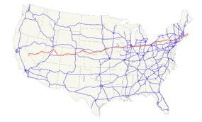
U.S. Route 6 (US 6), also called the Grand Army of the Republic Highway, honoring the American Civil War veterans association, is a main route of the U.S. Highway system. While it currently runs east-northeast from Bishop, California to Provincetown, Massachusetts, the route has been modified several times. The highway's longest-lasting routing, from 1936 to 1964, had its western terminus at Long Beach, California. During this time, US 6 was the longest highway in the country.
In 1964, the state of California renumbered its highways, and most of the route within California was transferred to other highways. This dropped the highway's length below that of US 20.
US 6 is a diagonal route, whose number is out of sequence with the rest of the U.S. Highway grid in the western US. When it was designated in 1926, US 6 only ran east of Erie, Pennsylvania. Subsequent extensions, largely replacing the former U.S. Route 32 (US 32) and U.S. Route 38 (US 38), have taken it south of US 30 near Chicago, Illinois, US 40 near Denver, Colorado (past the end of US 38), US 50 at Ely, Nevada, and even US 70 near Los Angeles, California, due to its north–south alignment in that state.
...
Wikipedia

