Interstate 94
| Interstate 94 | |
|---|---|
 |
|
| Route information | |
| Length: | 1,585.20 mi (2,551.13 km) |
| Existed: | 1956 – present |
| Major junctions | |
| West end: |
|
|
|
| East end: |
|
| Location | |
| States: | Montana, North Dakota, Minnesota, Wisconsin, Illinois, Indiana, Michigan |
| Highway system | |
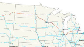
Interstate 94 (I-94) is an east–west Interstate Highway connecting the Great Lakes and Intermountain regions of the United States. I-94's western terminus is in Billings, Montana, at a junction with I-90; its eastern terminus is the U.S. side of the Blue Water Bridge in Port Huron, Michigan, at the Sarnia, Ontario, Canada, border, where together with I-69 it meets Highway 402, the only east–west Interstate Highway to form a direct connection into Canada. It lies along the primary overland route from Seattle (via I-90) to Toronto (via Ontario Highway 401).
I-94 is the eighth longest Interstate highway and the longest Interstate highway whose number does not end in a 0 or a 5.
I-94 intersects with I-90 several times: at its western terminus; near Madison, Wisconsin; in Chicago, and in Lake Station, Indiana.
I-94 begins at Billings and travels northeastward toward Glendive before exiting the state to the east. I-94 links seven counties, which are Yellowstone, Treasure, Rosebud, Custer, Prairie, Dawson, and Wibaux counties and passes near or through Miles City, and Glendive while connecting with I-90 in Billings. The Highway is notable for following the Yellowstone River from Billings through Glendive. Beyond the western terminus of I-94, I-90 connects westbound I-94 travelers to points west such as Butte and Seattle, WA.
...
Wikipedia

