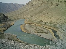
Arax River
| Aras | |
|---|---|

|
|

Aras River highlighted on a map of the Kura River watershed
|
|
| Country | Turkey, Armenia, Iran, Azerbaijan, Nagorno Karabakh Republic |
| Basin features | |
| Main source | Erzurum Province, Turkey |
| River mouth | Kura river |
| Basin size | 102,000 km2 (39,000 sq mi) |
| Physical characteristics | |
| Length | 1,072 km (666 mi) |
| Discharge |
|
The Aras or Araxes is a river in and along the countries of Turkey, Armenia, Azerbaijan, and Iran. It drains the south side of the Lesser Caucasus Mountains and then joins the Kura River which drains the north side of those mountains. Its total length is 1,072 kilometres (666 mi). Given its length and a basin that covers an area of 102,000 square kilometres (39,000 sq mi), it is one of the largest rivers of the Caucasus.
In the classical antiquity the river was known to the Greeks as Araxes (Greek: Αράξης). Its modern Armenian name is Araks or Arax (Armenian: Արաքս). Historically, it was known as Yeraskh (Classical Armenian: Երասխ). Its Old Georgian name is Rakhsi (რახსი). In other languages, it is known as Turkish: Aras;Persian: ارس, Aras; Kurdish: Erez; Azerbaijani: Araz.
The Aras rises near Erzurum, Turkey. It meets with the Akhurian River southeast of Digor, flows along the closed Turkish-Armenian border, and then near a corridor that connects Turkey to Azerbaijan's Nakhchivan exclave. It then flows along the Iranian-Armenian and the Iranian-Azerbaijan border.
...
Wikipedia
