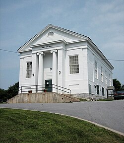
Orwell, Vermont
| Orwell, Vermont | |
|---|---|
| Town | |

Orwell town hall
|
|
| Nickname(s): "The Fortress of America" | |
| Motto: "First in Revolution, First in Recreation" | |
 Location in Addison County and the state of Vermont. |
|
| Coordinates: 43°48′30″N 73°17′1″W / 43.80833°N 73.28361°WCoordinates: 43°48′30″N 73°17′1″W / 43.80833°N 73.28361°W | |
| Country | United States |
| State | Vermont |
| County | Addison |
| Area | |
| • Total | 49.7 sq mi (128.6 km2) |
| • Land | 47.2 sq mi (122.2 km2) |
| • Water | 2.5 sq mi (6.5 km2) |
| Elevation | 381 ft (116 m) |
| Population (2010) | |
| • Total | 1,250 |
| • Density | 26/sq mi (10.2/km2) |
| Time zone | Eastern (EST) (UTC-5) |
| • Summer (DST) | EDT (UTC-4) |
| ZIP code | 05760 |
| Area code | 802 |
| FIPS code | 50-53725 |
| GNIS feature ID | 1462168 |
| Website | www |
Orwell is a town in Addison County, Vermont, United States. The population was 1,250 at the 2010 census.Mount Independence was the largest fortification constructed by the American colonial forces. The 300-acre (1.2 km2) site is now one of Vermont's premier state-operated historic sites.
Orwell is located in the southwest corner of Addison County. Its western border is the New York–Vermont state line, following the middle of Lake Champlain, near the lake's southern end. Orwell is bordered by the town of Shoreham to the north, Whiting to the northeast, Sudbury to the east and southeast, and Benson to the south. Sudbury and Benson are within Rutland County. To the west, across Lake Champlain, are the town of Putnam, New York, in Washington County, and Ticonderoga, New York, in Essex County. Mount Independence, elevation 306 feet (93 m), is located in northwest Orwell, overlooking Lake Champlain and the town of Ticonderoga.
According to the United States Census Bureau, Orwell has a total area of 49.7 square miles (128.6 km2), of which 47.2 square miles (122.2 km2) is land and 2.5 square miles (6.5 km2), or 5.02%, is water.
Vermont Route 22A runs through the town, leading north to Vergennes and south to Fair Haven, where it continues into New York. Vermont Route 73 crosses Route 22A west of the town center and leads east to Brandon and northwest to the Ticonderoga–Larrabees Point Ferry across Lake Champlain.
...
Wikipedia
