Addison County, Vermont
| Addison County, Vermont | |
|---|---|

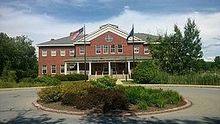
Addison County courthouse in Middlebury
|
|
 Location in the U.S. state of Vermont |
|
 Vermont's location in the U.S. |
|
| Founded | 1785 |
| Shire Town | Middlebury |
| Largest town | Middlebury |
| Area | |
| • Total | 808 sq mi (2,093 km2) |
| • Land | 766 sq mi (1,984 km2) |
| • Water | 41 sq mi (106 km2), 5.1% |
| Population (est.) | |
| • (2015) | 37,035 |
| • Density | 48/sq mi (19/km²) |
| Congressional district | At-large |
| Time zone | Eastern: UTC-5/-4 |
| Website | www |
Coordinates: 44°03′N 73°07′W / 44.050°N 73.117°W
Addison County is a county located in the state of Vermont, in the United States. At the 2010 census, the population was 36,821. Its shire town (county seat) is Middlebury.
Iroquois settled in the county before European arrived in 1609. French settlers in Crown Point, New York extended their settlements across Lake Champlain. A few individuals or families came up the lake from Canada and established themselves at Chimney Point in 1730. In 1731, at Cross Point Fort Frederic was erected. In the year 1759, General Amherst occupied Cross Point and British settler's settlers came in. The Battle of Bennington in Bennington, fought on August 16, 1777, brought a turning point for the American independence against British.
This county was established by act of the Legislature October 18, 1785. at the period of Vermont Republic. In 1791, Vermont joined the federal union after the original thirteen colonies. The main product of the county was wheat. In addition to wheat, farmers began to raise flocks on the field for manuring around the 1820s. The Champlain Canal was opened on 1823, so the ships could navigate from the Hudson River. In 1840, the county produced more wool than any other county in the United States.
...
Wikipedia
