Ticonderoga–Larrabees Point Ferry
| Route 74 | ||||||||||
|---|---|---|---|---|---|---|---|---|---|---|

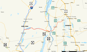
Map of Essex County in northeastern New York with NY 74 highlighted in solid red and of Addison County in western Vermont with VT 74 highlighted in dotted red
|
||||||||||
| Route information | ||||||||||
| Maintained by NYSDOT and VTrans | ||||||||||
| Length: | 33.713 mi (54.256 km) 20.45 mi in New York 13.263 mi in Vermont |
|||||||||
| History: | NY 74 designated NY 73 in 1930; renumbered to NY 74 c. 1973 VT 74 assigned mid-1950s |
|||||||||
| Major junctions | ||||||||||
| West end: |
|
|||||||||
|
|
||||||||||
| East end: |
|
|||||||||
| Location | ||||||||||
| Counties: | Essex (NY), Addison (VT) | |||||||||
| Highway system | ||||||||||
State highways in Vermont
|
||||||||||
New York State Route 74 (NY 74) and Vermont Route 74 (VT 74) are adjoining state highways in the northeastern United States, connected by one of the last remaining cable ferries in North America. Together they extend for 34 miles (55 km) through Essex County, New York, and Addison County, Vermont. NY 74 begins at exit 28 off Interstate 87 (I-87) in the hamlet of Severance in the Adirondack Mountains region of the northern part of New York State. It extends 20.44 miles (32.89 km) to the western shore of Lake Champlain in Ticonderoga. There, the seasonal Fort Ticonderoga–Larrabees Point Ferry carries cars across the state border into Vermont, where VT 74 starts at the lake's eastern shore and terminates 13.26 miles (21.34 km) later at a junction with VT 30 in the town of Cornwall.
NY 74 is a descendant of the historic Ticonderoga and Schroon Turnpike, which was a privately owned highway chartered in 1832, and segments of NY 74 follow the alignment of the original 19th-century turnpike. The connecting ferry route predates both NY 74 and VT 74 and began operation in 1759 on an informal basis. The ferry operation formalized at the close of the 18th century and upgraded to a cable system in 1946.
...
Wikipedia


