Eritrea
|
State of Eritrea |
|||||
|---|---|---|---|---|---|
|
|||||

Location of Eritrea (dark green)
– in Africa (dark grey) |
|||||
 |
|||||
| Capital and largest city |
Asmara 15°20′N 38°55′E / 15.333°N 38.917°E |
||||
| Official languages | None (de jure) Tigrinya (de facto) |
||||
| Recognised national languages | |||||
| Working languages | |||||
| Ethnic groups (2012) | |||||
| Demonym | Eritrean | ||||
| Government | Single-party presidential system | ||||
| Isaias Afwerki | |||||
| Legislature | National Assembly | ||||
| Formation | |||||
|
• Dʿmt
|
c. 980 BC | ||||
| c. 100 AD | |||||
| 1890 | |||||
| 15 September 1952 | |||||
|
• De facto State of Eritrea
|
24 May 1991 | ||||
|
• De jure State of Eritrea
|
24 May 1993 | ||||
| Area | |||||
|
• Total
|
117,600 km2 (45,400 sq mi) (101st) | ||||
|
• Water (%)
|
0.14% | ||||
| Population | |||||
|
• 2014 estimate
|
6,380,803 (107th) | ||||
|
• Density
|
51.8/km2 (134.2/sq mi) (154th) | ||||
| GDP (PPP) | 2017 estimate | ||||
|
• Total
|
$9.121 billion | ||||
|
• Per capita
|
$1,332 | ||||
| GDP (nominal) | 2017 estimate | ||||
|
• Total
|
$6.047 billion | ||||
|
• Per capita
|
$843 | ||||
| HDI (2014) |
low · 186th |
||||
| Currency | Nakfa (ERN) | ||||
| Time zone | EAT (UTC+3) | ||||
|
• Summer (DST)
|
not observed (UTC+3) | ||||
| Drives on the | right | ||||
| Calling code | +291 | ||||
| ISO 3166 code | ER | ||||
| Internet TLD | .er | ||||
Coordinates: 15°N 39°E / 15°N 39°E
– in Africa (dark grey)
– in the African Union (dark grey)
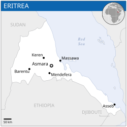
Eritrea (/ˌɛrᵻˈtreɪ.ə/ or /ˌɛrᵻˈtriːə/), officially the State of Eritrea, is a country in the Horn of Africa. With its capital at Asmara, it is bordered by Sudan in the west, Ethiopia in the south, and Djibouti in the southeast. The northeastern and eastern parts of Eritrea have an extensive coastline along the Red Sea. The nation has a total area of approximately 117,600 km2 (45,406 sq mi), and includes the Dahlak Archipelago and several of the Hanish Islands. Its toponym Eritrea is based on the Greek name for the Red Sea (Ἐρυθρὰ Θάλασσα Erythra Thalassa), which was first adopted for Italian Eritrea in 1890.
...
Wikipedia


