Bodegraven
| Bodegraven | |||
|---|---|---|---|
| Town and former municipality | |||

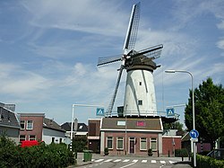
Windmill De Arkduif
|
|||
|
|||
 |
|||
| Coordinates: 52°5′9″N 4°44′40″E / 52.08583°N 4.74444°ECoordinates: 52°5′9″N 4°44′40″E / 52.08583°N 4.74444°E | |||
| Country | Netherlands | ||
| Province | South Holland | ||
| Municipality | Bodegraven-Reeuwijk | ||
| Area(2006) | |||
| • Total | 38.50 km2 (14.86 sq mi) | ||
| • Land | 37.48 km2 (14.47 sq mi) | ||
| • Water | 1.02 km2 (0.39 sq mi) | ||
| Population (1 January 2007) | |||
| • Total | 19,348 | ||
| • Density | 516/km2 (1,340/sq mi) | ||
| Source: CBS, Statline. | |||
| Time zone | CET (UTC+1) | ||
| • Summer (DST) | CEST (UTC+2) | ||
| Website | www.bodegraven.nl | ||
Bodegraven (![]() pronunciation ) is a town and former municipality in the western Netherlands, in the province of South Holland. The former municipality covers an area of 38.50 km2 (14.86 sq mi) of which 1.02 km2 (0.39 sq mi) is water.
pronunciation ) is a town and former municipality in the western Netherlands, in the province of South Holland. The former municipality covers an area of 38.50 km2 (14.86 sq mi) of which 1.02 km2 (0.39 sq mi) is water.
The former municipality of Bodegraven also includes the communities Meije, and Nieuwerbrug.
On January 1, 2011 Bodegraven merged with Reeuwijk to Bodegraven-Reeuwijk.
Bodegraven is centrally located in the Green Heart of the Randstad, roughly equally distant (about 30 km) from Amsterdam, Rotterdam, The Hague, and Utrecht. It is surrounded by the municipalities (clockwise, starting in the north): Nieuwkoop, Woerden, Reeuwijk (former municipality), Boskoop, and Alphen aan den Rijn.
The town is situated on both shores of the Oude Rijn, in which a set of locks are in the middle of town. The oldest part of town is the Reformed St. Gallus Church, on the north side of the river.
...
Wikipedia


