Woerden
| Woerden | |||
|---|---|---|---|
| City and Municipality | |||

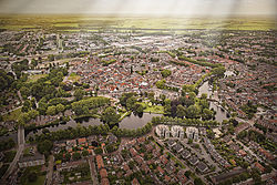
Aerial view of Woerden in 2013
|
|||
|
|||
 Location in Utrecht |
|||
| Coordinates: 52°5′N 4°53′E / 52.083°N 4.883°ECoordinates: 52°5′N 4°53′E / 52.083°N 4.883°E | |||
| Country | Netherlands | ||
| Province | Utrecht | ||
| Government | |||
| • Body | Municipal council | ||
| • Mayor | Victor Molkenboer (PvdA) | ||
| Area | |||
| • Total | 92.92 km2 (35.88 sq mi) | ||
| • Land | 89.35 km2 (34.50 sq mi) | ||
| • Water | 3.57 km2 (1.38 sq mi) | ||
| Elevation | 0 m (0 ft) | ||
| Population (May 2014) | |||
| • Total | 50,593 | ||
| • Density | 566/km2 (1,470/sq mi) | ||
| Demonym(s) | Woerdenaar | ||
| Time zone | CET (UTC+1) | ||
| • Summer (DST) | CEST (UTC+2) | ||
| Postcode | 3440–3449, 3470–3481 | ||
| Area code | 0348 | ||
| Website | www |
||
Woerden (Dutch pronunciation: [ˈʋurdən]) is a city and a municipality in the central Netherlands. Due to its central location between Amsterdam, Rotterdam, The Hague and Utrecht, and the fact that it has rail and road connections to those cities, it is a popular town for commuters who work in those cities.
The river Oude Rijn used to flow through the city center of Woerden, but in 1960 the old river was diverted around the city center. The city has a long and rich history in cheese making and trading; for years Gouda cheese for domestic and international use has been produced in this region. Woerden still holds its authentic (since 1885) cheese market at the market place in its center.
Woerden is situated on the river Oude Rijn, near the confluence with the former Linschoten (water) stream. The lower stretch of the Linschoten stream from Montfoort and Linschoten to Woerden silted up a long time ago and its flow was diverted through the Lek and Hollandse IJssel rivers, but at one time it was an important branch of the Rhine delta, connecting the Lower Rhine from Wijk bij Duurstede to the Oude Rijn near Woerden. Near the former confluence was an area that was slightly more elevated than the surroundings, a natural levee, which -in an area that is prone to flooding- made it an attractive location for settlement.
Here, at the highest spot, the Romans built a castellum (Castellum Laurum), as part of the limes of the Roman Empire and thus part of the defense lines of the northern border of the Roman Empire. The first castellum was built in the 40s AD, and was destroyed in 69 AD during the Batavian rebellion. In 70 AD the castellum was rebuilt, and the Romans remained until 402 AD, with an interruption lasting from about 275-300 AD.
...
Wikipedia


