Linschoten (village)
| Linschoten | |||
|---|---|---|---|
| Town | |||
 |
|||
|
|||
 |
|||
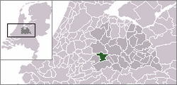
 The town centre (dark green) and the statistical district (light green) of Linschoten in the municipality of Montfoort. |
|||
| Coordinates: 52°3′46″N 4°54′52″E / 52.06278°N 4.91444°ECoordinates: 52°3′46″N 4°54′52″E / 52.06278°N 4.91444°E | |||
| Country | Netherlands | ||
| Province | Utrecht | ||
| Municipality | Montfoort | ||
| Population (2003) | |||
| • Total | 5,000 | ||
| Time zone | CET (UTC+1) | ||
| • Summer (DST) | CEST (UTC+2) | ||
Linschoten (Dutch pronunciation: [ˈlɪnsxoːtə(n)]) is a village in the Dutch province of Utrecht. It is a part of the municipality of Montfoort, and lies about 3 km southeast of Woerden.
In 2001, the village of Linschoten had 3588 inhabitants. It had a built-up area of 0.65 km² with 1288 residences. The statistical area "Linschoten", which also can include the peripheral parts of the village, as well as the surrounding countryside, has a population of around 3910.
...
Wikipedia


