2006–07 South-West Indian Ocean cyclone season
| 2006–07 South-West Indian Ocean cyclone season |
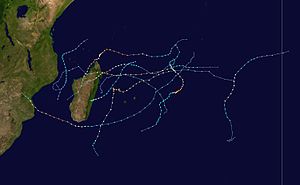
Season summary map
|
| Seasonal boundaries |
| First system formed |
October 19, 2006 |
| Last system dissipated |
April 12, 2007 |
| Strongest storm |
|
| Name |
Dora and Favio |
| • Maximum winds |
195 km/h (120 mph)
(10-minute sustained) |
| • Lowest pressure |
925 hPa (mbar) |
| Seasonal statistics |
| Total disturbances |
15 |
| Total depressions |
11 |
| Total storms |
10 |
| Tropical cyclones |
7 |
| Intense tropical cyclones |
6 (record high)
|
| Total fatalities |
188 (126 missing) |
| Total damage |
$337 million (2007 USD) |
| Related articles |
|
|
South-West Indian Ocean tropical cyclone seasons
2004–05, 2005–06, 2006–07, 2007–08, 2008–09
|
| Tropical disturbance (MFR) |
|
|
| Duration |
October 19 – October 23 |
| Peak intensity |
45 km/h (30 mph) (10-min) 1002 hPa (mbar) |
| Moderate tropical storm (MFR) |
| Tropical storm (SSHWS) |
|
|
| Duration |
November 26 – December 4 |
| Peak intensity |
65 km/h (40 mph) (10-min) 996 hPa (mbar) |
| Intense tropical cyclone (MFR) |
| Category 4 tropical cyclone (SSHWS) |
|
|
| Duration |
December 15 – December 28 |
| Peak intensity |
205 km/h (125 mph) (10-min) 930 hPa (mbar) |
| Tropical disturbance (MFR) |
|
|
| Duration |
December 22 – December 28 |
| Peak intensity |
45 km/h (30 mph) (10-min) 1000 hPa (mbar) |
| Severe tropical storm (MFR) |
| Category 1 tropical cyclone (SSHWS) |
|
|
| Duration |
December 29 – January 4 |
| Peak intensity |
115 km/h (70 mph) (10-min) 978 hPa (mbar) |
| Tropical disturbance (MFR) |
|
|
| Duration |
January 5 – January 8 |
| Peak intensity |
45 km/h (30 mph) (10-min) 999 hPa (mbar) |
| Intense tropical cyclone (MFR) |
| Category 4 tropical cyclone (SSHWS) |
|
|
| Duration |
January 26 – February 8 |
| Peak intensity |
195 km/h (120 mph) (10-min) 925 hPa (mbar) |
| Severe tropical storm (MFR) |
| Tropical storm (SSHWS) |
|
|
| Duration |
February 6 – February 13 |
| Peak intensity |
115 km/h (70 mph) (10-min) 978 hPa (mbar) |
| Intense tropical cyclone (MFR) |
| Category 4 tropical cyclone (SSHWS) |
|
|
| Duration |
February 11 – February 23 |
| Peak intensity |
195 km/h (120 mph) (10-min) 925 hPa (mbar) |
The 2006–07 South-West Indian Ocean cyclone season was a slightly above average event in tropical cyclone formation which started on November 15, 2006 and ended on April 30, 2007 for most areas and on May 15, 2007 for Mauritius and the Seychelles. These dates conventionally delimit the period of each year when most tropical cyclones form in the basin, which is west of 90°E and south of the Equator. Tropical cyclones in this basin are monitored by the Regional Specialised Meteorological Centre in Réunion.
On October 13, 2006, the Mauritius Meteorological Services issued their seasonal outlook for the Southwest Indian Ocean. They forecast an El Niño-positive phase for the season, meaning that normal to slightly above normal activity was likely. They also forecast a weak Quasi-Biennial Oscillation, which favoured formation of tropical storms, and noted that as 2006 Northern Hemisphere activity was slightly below normal, it might result in slightly above normal activity in the Southwest Indian Ocean. Based on regional indicators, they noted that named tropical storms would not last for short durations. Most other regional factors indicated the likelihood of a normal season. Therefore, the forecast called for about 10 named storms, mostly west of Diego Garcia, with at least one forming in the Mozambique Channel.
On October 19, a disturbed area of low pressure near the equator that had persisted for about two days was designated the year's first tropical disturbance by the RSMC on La Réunion. During the following three days, no regular advisories were released because the disturbance was not expected to develop. On October 22, however, the disturbance restrengthened and the issuance of full advisories began because development into a tropical depression was expected. This development did not occur, and on October 23 the final advisory was issued.
On November 25, an area of convection developed near 5°S 55°E . The system was designated a zone perturbée two days later by RSMC La Réunion. It strengthened slightly, and was declared a tropical disturbance on November 27 at 1200 UTC. The Joint Typhoon Warning Center monitored the area for development and on November 29 upgraded the disturbance to a cyclone. RSMC La Réunion upgraded this system to a moderate tropical storm on December 1, and the Subregional Tropical Cyclone Advisory Centre in Madagascar named it "Anita", a name contributed to the list by themselves. Increasing wind shear inhibited any development, and the system failed to intensify further as it moved southward. RSMC La Réunion downgraded Anita to a tropical depression early on December 2. The JTWC ceased advisories on the system at the same time. Anita continued to weaken, and RSMC La Réunion downgraded it to a tropical disturbance later that day, and issued its last advisory early on December 3.
...
Wikipedia


