2008–09 South-West Indian Ocean cyclone season
| 2008–09 South-West Indian Ocean cyclone season |
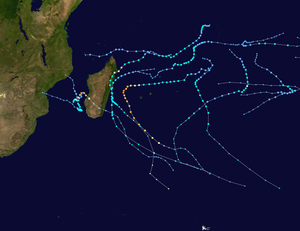
Season summary map
|
| Seasonal boundaries |
| First system formed |
October 6, 2008 |
| Last system dissipated |
April 10, 2009 |
| Strongest storm |
|
| Name |
Fanele and Gael |
| • Maximum winds |
185 km/h (115 mph) |
| • Lowest pressure |
930 hPa (mbar) |
| Seasonal statistics |
| Total disturbances |
12 |
| Total depressions |
10 |
| Total storms |
10 |
| Tropical cyclones |
2 |
| Intense tropical cyclones |
2 |
| Total fatalities |
30 direct, 2 missing |
| Total damage |
Unknown |
| Related articles |
|
|
South-West Indian Ocean tropical cyclone seasons
2006–07, 2007–08, 2008–09, 2009–10, 2010–11
|
| Zone of Disturbed Weather (MFR) |
|
|
| Duration |
October 6 – October 8 |
| Peak intensity |
35 km/h (25 mph) (10-min) 1006 hPa (mbar) |
| Moderate tropical storm (MFR) |
| Tropical storm (SSHWS) |
|
|
| Duration |
October 15 – October 24 |
| Peak intensity |
85 km/h (50 mph) (10-min) 988 hPa (mbar) |
| Moderate tropical storm (MFR) |
| Tropical storm (SSHWS) |
|
|
| Duration |
November 13 – November 21 |
| Peak intensity |
65 km/h (40 mph) (10-min) 995 hPa (mbar) |
| Severe tropical storm (MFR) |
| Tropical storm (SSHWS) |
|
|
| Duration |
December 13 – December 24 |
| Peak intensity |
95 km/h (60 mph) (10-min) 985 hPa (mbar) |
| Severe tropical storm (MFR) |
| Tropical storm (SSHWS) |
|
|
| Duration |
January 7 – January 12 |
| Peak intensity |
95 km/h (60 mph) (10-min) 984 hPa (mbar) |
| Moderate tropical storm (MFR) |
| Tropical storm (SSHWS) |
|
|
| Duration |
January 16 – January 22 |
| Peak intensity |
85 km/h (50 mph) (10-min) 990 hPa (mbar) |
| Intense tropical cyclone (MFR) |
| Category 4 tropical cyclone (SSHWS) |
|
|
| Duration |
January 17 – January 22 |
| Peak intensity |
185 km/h (115 mph) (10-min) 930 hPa (mbar) |
| Intense tropical cyclone (MFR) |
| Category 4 tropical cyclone (SSHWS) |
|
|
| Duration |
February 1 – February 9 |
| Peak intensity |
185 km/h (115 mph) (10-min) 930 hPa (mbar) |
| Severe tropical storm (MFR) |
| Category 1 tropical cyclone (SSHWS) |
|
|
| Duration |
February 20 – February 26 |
| Peak intensity |
105 km/h (65 mph) (10-min) 976 hPa (mbar) |
The 2008–09 South-West Indian Ocean cyclone season was a slightly above average event in tropical cyclone formation. It began on November 15, 2008, and officially ended on April 30, 2009, with the exception for Mauritius and the Seychelles, for which it ended on May 15, 2009. These dates conventionally delimit the period of each year when most tropical cyclones form in the basin, which is west of 90°E and south of the Equator. Tropical cyclones in this basin were monitored by the Regional Specialised Meteorological Centre in Réunion.
As predicted by the sub regional office of Mauritius ten named storms formed in this basin. It officially began on November 15, but began 1 month earlier when Tropical Storm Asma formed on October 16. Most of the storms that formed this year were weak or stayed at sea. Only two storms reached hurricane strength this year, both of which were Category 3 or higher, and only 3 storms made landfall in the entire season. Overall, the impact of this season was relatively minor, but damaging for Madagascar, due to the heavy rains from Eric, Fanele, Izilda and Jade.
On October 6, the Joint Typhoon Warning Center (JTWC) began monitoring an area of persistent convection about 575 km (355 mi) southeast of Diego Garcia. Although the center of circulation (CoC) was elongated, the system was located within an area of low wind shear and development of the low was possible. At 12:00 UTC later that day, the Regional Specialized Meteorological Centre (RSMC), Météo-France (MFR), began issuing advisories on "Zone of Disturbed Weather 01". Despite a banding feature developed around the CoC, significant development was not anticipated. The low gradually weakened throughout October 7, and dissipated the next day.
...
Wikipedia


