Diego Garcia

Aerial photograph of Diego Garcia
|
|
| Location of Diego Garcia | |
| Geography | |
|---|---|
| Coordinates | 7°18′48″S 72°24′40″E / 7.31333°S 72.41111°ECoordinates: 7°18′48″S 72°24′40″E / 7.31333°S 72.41111°E |
| Archipelago | Chagos Archipelago |
| Adjacent bodies of water | Indian Ocean |
| Area | 30 km2 (12 sq mi) |
| Administration | |
| Largest settlement | Eclipse Point Town |
| Demographics | |
| Population | 4,239 |
| Additional information | |
| Time zone | |
| Designated | 4 July 2001 |
Diego Garcia is an atoll just south of the equator in the central Indian Ocean, and the largest of 60 small islands comprising the Chagos Archipelago. It was settled by the French in the 1790s and was transferred to British rule after the Napoleonic Wars. It was one of the "Dependencies" of the British Colony of Mauritius until it was detached for inclusion in the newly created British Indian Ocean Territory (BIOT) in 1965. Between 1968 and 1973, the population was forcibly removed by the United Kingdom through intimidation of locals and denying the return of any who left the island. Many were deported to Mauritius and Seychelles, following which the United States built a large naval and military base on Diego Garcia, which has been in continuous operation ever since. As of March 2015[update], Diego Garcia is the only inhabited island of the BIOT; the population is composed of military personnel and supporting contractors.
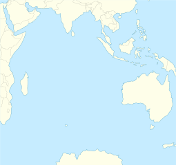
The atoll is located 3,535 km (2,197 mi) east of Tanzania's coast, 1,796 km (1,116 mi) south-southwest of the southern tip of India (at Kanyakumari) and 4,723 km (2,935 mi) west-northwest of the west coast of Australia (at Cape Range National Park, Western Australia). Diego Garcia lies at the southernmost tip of the Chagos-Laccadive Ridge, a vast submarine mountain range, top of coral reefs, atolls, and islands comprising Lakshadweep, The Maldives, and the Chagos Archipelago. Local time is UTC+6 year-round (DST is not observed).
...
Wikipedia

