2004–05 South-West Indian Ocean cyclone season
| 2004–05 South-West Indian Ocean cyclone season |

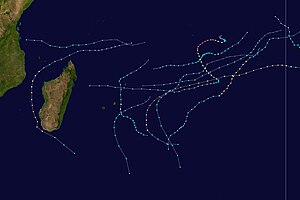
Season summary map
|
| Seasonal boundaries |
| First system formed |
August 30, 2004 |
| Last system dissipated |
April 11, 2005 |
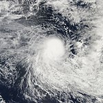
| Strongest storm |
|
| Name |
Juliet |
| • Maximum winds |
220 km/h (140 mph)
(10-minute sustained) |
| • Lowest pressure |
905 hPa (mbar) |
| Seasonal statistics |
| Total disturbances |
18 |
| Total depressions |
15 |
| Total storms |
10 official, 1 unofficial |
| Tropical cyclones |
4 |
| Intense tropical cyclones |
3 |
| Very intense tropical cyclones |
2 (record high, tied with 2013–14 and 2014–15)
|
| Total fatalities |
19-233 |
| Total damage |
Unknown |
| Related articles |
|
|
South-West Indian Ocean tropical cyclone seasons
2002–03, 2003–04, 2004–05, 2005–06, 2006–07
|
| Tropical depression (MFR) |
| Tropical depression (SSHWS) |
|
|
| Duration |
August 30 – September 1 (Crossed 90°E)
|
| Peak intensity |
55 km/h (35 mph) (10-min) 999 hPa (mbar) |
| Tropical depression (MFR) |
| Tropical storm (SSHWS) |
|
|
| Duration |
October 25 – October 29 |
| Peak intensity |
55 km/h (35 mph) (10-min) 996 hPa (mbar) |
| Severe tropical storm (MFR) |
| Category 1 tropical cyclone (SSHWS) |
|
|
| Duration |
November 6 – November 18 |
| Peak intensity |
110 km/h (70 mph) (10-min) 978 hPa (mbar) |
| Very intense tropical cyclone (MFR) |
| Category 5 tropical cyclone (SSHWS) |
|
|
| Duration |
November 19 – December 4 |
| Peak intensity |
220 km/h (140 mph) (10-min) 915 hPa (mbar) |
| Subtropical Disturbance (MFR) |
|
|
| Duration |
December 11 – December 11 |
| Peak intensity |
45 km/h (30 mph) (10-min) 1000 hPa (mbar) |
| Tropical cyclone (MFR) |
| Category 3 tropical cyclone (SSHWS) |
|
|
| Duration |
December 22 – December 28 |
| Peak intensity |
155 km/h (100 mph) (10-min) 950 hPa (mbar) |
| Tropical depression (MFR) |
|
|
| Duration |
January 4 – January 5 |
| Peak intensity |
55 km/h (35 mph) (10-min) 998 hPa (mbar) |
| Severe tropical storm (MFR) |
| Tropical storm (SSHWS) |
|
|
| Duration |
January 17 – January 23 |
| Peak intensity |
95 km/h (60 mph) (10-min) 985 hPa (mbar) |
| Intense tropical cyclone (MFR) |
| Category 3 tropical cyclone (SSHWS) |
|
|
| Duration |
January 16 – January 23 |
| Peak intensity |
165 km/h (105 mph) (10-min) 950 hPa (mbar) |
The 2004–05 South-West Indian Ocean cyclone season was a slightly above average event in tropical cyclone formation. It started on November 15, 2004 and ended on April 30, 2005. For Mauritius and the Seychelles, the season continued until May 15. These dates conventionally delimit the period of each year when most tropical cyclones form in the basin, which is west of 90°E and south of the Equator. Tropical cyclones in this basin are monitored by the Regional Specialised Meteorological Centre in Réunion.
On August 30, an area of low pressure developed near the edge of Météo-France's area of responsibility within an unseasonably active monsoonal band which coincided with the Madden–Julian oscillation. Tracking towards the southeast, the low experience strong deep-level wind shear which kept most of the convection displaced from the center of circulation. On August 31, convection managed to develop around the west and southwestern portions of the low before and was designated as Tropical Depression 01. The depression reached its peak intensity at this time with winds of 55 km/h (35 mph 10-minute winds) and a minimum pressure of 999 hPa (mbar). Shortly after, the depression entered Australian Bureau of Meteorology in Perth's area of responsibility. The depression later intensified into a tropical cyclone and was named Phoebe.
...
Wikipedia


