2014–15 South-West Indian Ocean cyclone season
| 2014–15 South-West Indian Ocean cyclone season |
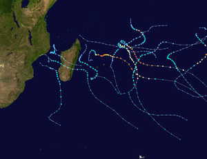
Season summary map
|
| Seasonal boundaries |
| First system formed |
November 15, 2014 |
| Last system dissipated |
April 11, 2015 |
| Strongest storm |
|
| Name |
Bansi |
| • Maximum winds |
220 km/h (140 mph)
(10-minute sustained) |
| • Lowest pressure |
910 hPa (mbar) |
| Seasonal statistics |
| Total disturbances |
14 |
| Total depressions |
13 |
| Total storms |
11 |
| Tropical cyclones |
4 |
| Intense tropical cyclones |
3 |
| Very intense tropical cyclones |
2 |
| Total fatalities |
111 total |
| Total damage |
$46.4 million (2015 USD) |
| Related articles |
|
|
South-West Indian Ocean tropical cyclone seasons
2012–13, 2013–14, 2014–15, 2015–16, 2016–17
|
| Severe tropical storm (MFR) |
| Category 1 tropical cyclone (SSHWS) |
|
|
| Duration |
November 15 – November 21 |
| Peak intensity |
110 km/h (70 mph) (10-min) 987 hPa (mbar) |
| Tropical depression (MFR) |
| Tropical storm (SSHWS) |
|
|
| Duration |
November 24 – November 30 |
| Peak intensity |
60 km/h (35 mph) (10-min) 997 hPa (mbar) |
| Intense tropical cyclone (MFR) |
| Category 3 tropical cyclone (SSHWS) |
|
|
| Duration |
December 30 (Entered basin) – December 31 |
| Peak intensity |
165 km/h (105 mph) (10-min) 950 hPa (mbar) |
| Very intense tropical cyclone (MFR) |
| Category 5 tropical cyclone (SSHWS) |
|
|
| Duration |
January 10 – January 18 |
| Peak intensity |
220 km/h (140 mph) (10-min) 910 hPa (mbar) |
| Severe tropical storm (MFR) |
| Tropical storm (SSHWS) |
|
|
| Duration |
January 14 – January 19 |
| Peak intensity |
105 km/h (65 mph) (10-min) 975 hPa (mbar) |
| Moderate tropical storm (MFR) |
| Tropical storm (SSHWS) |
|
|
| Duration |
January 26 – January 30 |
| Peak intensity |
85 km/h (50 mph) (10-min) 986 hPa (mbar) |
| Very intense tropical cyclone (MFR) |
| Category 5 tropical cyclone (SSHWS) |
|
|
| Duration |
January 27 – February 1 |
| Peak intensity |
230 km/h (145 mph) (10-min) 915 hPa (mbar) |
| Severe tropical storm (MFR) |
| Tropical storm (SSHWS) |
|
|
| Duration |
February 5 – February 8 |
| Peak intensity |
100 km/h (65 mph) (10-min) 978 hPa (mbar) |
| Severe tropical storm (MFR) |
| Tropical storm (SSHWS) |
|
|
| Duration |
February 22 – February 28 |
| Peak intensity |
95 km/h (60 mph) (10-min) 974 hPa (mbar) |
The 2014–15 South-West Indian Ocean cyclone season was an event of the annual cycle of tropical cyclone and subtropical cyclone formation. It began on November 15, 2014, and ended on April 30, 2015, with the exception for Mauritius and the Seychelles, for which it ended on May 15, 2015. These dates conventionally delimit the period of each year when most tropical and subtropical cyclones form in the basin, which is west of 90°E and south of the Equator. Tropical and subtropical cyclones in this basin are monitored by the Regional Specialised Meteorological Centre in Réunion.
During October 2014, the Mauritius Meteorological Services issued its seasonal outlook for the summer of 2014–15 and predicted that between ten and twelve named storms would develop during the season. The first tropical disturbance of the season developed on November 16, and quickly developed into the first named storm of the season and was named Adjali by Mauritius.
An area of low pressure developed close to Diego Garcia on November 14. It slowly organized as it made a northwest-south-southeast loop over the next two days. By the evening of November 16, the center of the storm became more well defined with convective rainbands wrapped tightly into it. Around that time, RSMC La Réunion started tracking the system as a tropical disturbance, and subsequently upgraded it to a Tropical Depression. Later that day, the JTWC issued a tropical cyclone formation alert on the system. The depression strengthened further and became the first named tropical storm of the year, on the same day. Mauritius Meteorological Service, which usually names storms in the region, named the system Adjali. The JTWC also initiated advisories on Adjali. On November 17, MFR upgraded it to a Severe Tropical Storm.On November 20, Adjali turned west until reached the northern tip of Madagascar on November 23 and rapidly dissipated.
During November 25, RSMC La Reunion reported that Tropical Disturbance 2, had developed within a marginal environment for further development to the northeast of the Mascarene islands.During that day despite having a low-level circulation centre that was located to the east of the deepest atmospheric convection, the system developed into a tropical depression. The depression continued to intensified as it was classified as a tropical storm by the JTWC early on November 28. The next day, the system moved in a southwestward direction and cooler waters. With this, the MFR downgraded it to a tropical disturbance again on November 29, with the JTWC downgrading it to a tropical depression.
...
Wikipedia


