2005-06 Australian region cyclone season
| 2005–06 Australian region cyclone season |
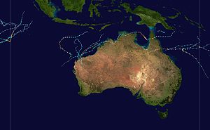
Season summary map
|
| Seasonal boundaries |
| First system formed |
5 November 2005 |
| Last system dissipated |
26 April 2006 |
| Strongest storm |
|
| Name |
Glenda |
| • Maximum winds |
220 km/h (140 mph)
(10-minute sustained) |
| • Lowest pressure |
910 hPa (mbar) |
| Seasonal statistics |
| Tropical lows |
18 |
| Tropical cyclones |
14 |
| Severe tropical cyclones |
9 |
| Total fatalities |
1 indirect |
| Total damage |
$808 million (2006 USD) |
| Related articles |
|
|
Australian region tropical cyclone seasons
2003–04, 2004–05, 2005–06, 2006–07, 2007–08
|
| Tropical low (Australian scale) |
| Tropical storm (SSHWS) |
|
|
| Duration |
5 November – 6 November (out of area)
|
| Peak intensity |
55 km/h (35 mph) (10-min) 995 hPa (mbar) |
| Category 4 severe tropical cyclone (Australian scale) |
| Category 4 tropical cyclone (SSHWS) |
|
|
| Duration |
19 November – 24 November (out of area)
|
| Peak intensity |
185 km/h (115 mph) (10-min) 928 hPa (mbar) |
| Tropical low (Australian scale) |
| Tropical depression (SSHWS) |
|
|
| Duration |
21 December – 23 December (out of area)
|
| Peak intensity |
55 km/h (35 mph) (10-min) 998 hPa (mbar) |
| Category 3 severe tropical cyclone (Australian scale) |
| Tropical storm (SSHWS) |
|
|
| Duration |
6 January – 10 January |
| Peak intensity |
140 km/h (85 mph) (10-min) 960 hPa (mbar) |
| Category 2 tropical cyclone (Australian scale) |
| Tropical storm (SSHWS) |
|
|
| Duration |
18 January – 22 January |
| Peak intensity |
100 km/h (65 mph) (10-min) 976 hPa (mbar) |
| Tropical low (Australian scale) |
|
|
| Duration |
24 January – 1 February |
| Peak intensity |
55 km/h (35 mph) (10-min) 989 hPa (mbar) |
| Category 3 severe tropical cyclone (Australian scale) |
| Category 1 tropical cyclone (SSHWS) |
|
|
| Duration |
25 January – 30 January (out of area)
|
| Peak intensity |
120 km/h (75 mph) (10-min) 970 hPa (mbar) |
| Category 2 tropical cyclone (Australian scale) |
| Tropical storm (SSHWS) |
|
|
| Duration |
22 February – 24 February |
| Peak intensity |
95 km/h (60 mph) (10-min) 985 hPa (mbar) |
| Category 1 tropical cyclone (Australian scale) |
| Tropical storm (SSHWS) |
|
|
| Duration |
25 February – 1 March |
| Peak intensity |
75 km/h (45 mph) (10-min) 988 hPa (mbar) |
The 2005–06 Australian region cyclone season was an above average tropical cyclone season. It began on 1 November 2005 and ended on 30 April 2006. The regional tropical cyclone operational plan also defines a tropical cyclone year separately from a tropical cyclone season, which runs from 1 July 2005 to 30 June 2006.
Tropical cyclones in this area are monitored by four Tropical Cyclone Warning Centres (TCWCs): the Australian Bureau of Meteorology in Perth, Darwin, and Brisbane; and TCWC Port Moresby in Papua New Guinea.
An area of convection persisted on 4 November about 560 km (345 mi) north of the Cocos Islands, associated with a tight low-level circulation. With good outflow and moderate but decreasing wind shear, conditions favored development. By early on 5 November, the system consisted of a partially exposed circulation with deep convection on its western side, tracking southwestward. At 0400 UTC that day, the Tropical Cyclone Warning Centre (TCWC) in Perth issued a gale warning in association with the disturbance. Later in the day, the Joint Typhoon Warning Center (JTWC) classified it as Tropical Cyclone 02S, and both the JTWC and TCWC Perth anticipated further strengthening.
Throughout its duration, TCWC Perth maintained the system as a 55 km/h (35 mph) tropical low. However, the JTWC assessed the storm as reaching peak winds of 85 km/h (50 mph), based on observations indicating the consolidation of convection over the center. The agency forecast the storm to strengthen further; however, by late on 6 November it had begun weakening. Around the same time, the storm crossed into the area of responsibility of Météo-France in Réunion (MFR); as such, it was re-designated as Tropical Depression 04. The depression continued southwestward as it slowly weakened. Early on 8 November, the JTWC issued its final warning, and six hours later, the MFR discontinued advisories while it was located about 1485 km (920 mi) southeast of Diego Garcia.
...
Wikipedia


.jpg)


