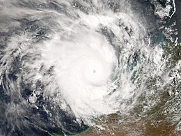
Cyclone Glenda
| Category 5 severe tropical cyclone (Aus scale) | |
|---|---|
| Category 4 (Saffir–Simpson scale) | |

Cyclone Glenda near peak intensity
|
|
| Formed | 23 March 2006 |
| Dissipated | 31 March 2006 |
| Highest winds |
10-minute sustained: 205 km/h (125 mph) 1-minute sustained: 220 km/h (140 mph) Gusts: 295 km/h (185 mph) |
| Lowest pressure | 910 hPa (mbar); 26.87 inHg |
| Fatalities | None reported |
| Damage | $965,000 (2006 USD) |
| Areas affected | Australia |
| Part of the 2005–06 Australian region cyclone season | |
Severe Tropical Cyclone Glenda (JTWC designation: 20S, also known as simply Cyclone Glenda) of March 2006 was among the strongest tropical cyclones to threaten Western Australia, though it weakened considerably before landfall and moved ashore in a lightly populated region. It began as a tropical low on 15 March in the Gulf of Carpentaria. The precursor disturbance drifted over Top End and later across the northeastern portion of Western Australia, and after emerging into the Indian Ocean it strengthened into a tropical storm. Aided by favourable environmental conditions, Glenda rapidly intensified to reach Category 5 status on the Australian cyclone scale, and with a peak intensity of 910 mbar it was among the strongest cyclones on record within the Australia region. On 30 March it moved ashore near Onslow as a Category 3 cyclone, and the next day it degenerated into a remnant tropical low over land.
The precursor disturbance produced heavy rainfall in the Kimberley region of Western Australia, causing record flooding and some road damage. Minor damage was reported at the final landfall of Glenda. Due to the sparse population and preparations made, the cyclone was not responsible for any deaths or injuries. However, its name was later retired from the list of tropical cyclone names.
On 15 March, a tropical disturbance developed in the south-western Gulf of Carpentaria. It moved westward, drifting across Top End, and it exited into the Joseph Bonaparte Gulf on 22 March. The Bureau of Meteorology (BoM) office in Darwin, which is the local Tropical Cyclone Warning Centre, began issuing advisories on the system late on 23 March while it was located about 85 km (50 mi) east-south-east of Wyndham, Western Australia. Environmental conditions favored intensification as an anticyclone developed over the storm, which provided good outflow and low vertical wind shear. Initially, the primary inhibiting factor was land interaction. After executing a small loop over water, the disturbance continued westward, crossing over the northern portion of Western Australia before emerging into the Indian Ocean on 26 March. It began tracking west-southwestward just offshore of the Kimberley coastline, and its convection quickly concentrated. At 0000 UTC on 27 March, the Joint Typhoon Warning Center (JTWC) classified it as Tropical Cyclone 20S. Three hours later, the BoM office in Perth upgraded the storm to Tropical Cyclone Glenda about 260 km (160 mi) north of Derby, Western Australia.
...
Wikipedia
