Geography of Turkey
 |
|
| Continent | Asia |
|---|---|
| Region | Southeastern Europe and Western Asia |
| Coordinates | 39°00′N 35°00′E / 39.000°N 35.000°E |
| Area | Ranked 37th |
| • Total | 783,562 km2 (302,535 sq mi) |
| • Land | 98% |
| • Water | 2% |
| Coastline | 7,200 km (4,500 mi) |
| Borders |
Total land borders: 2648 km Armenia 268 km, Azerbaijan 9 km, Bulgaria 240 km, Georgia 252 km, Greece 206 km, Iran 499 km, Iraq 352 km, Syria 822 km |
| Highest point |
Mount Ağrı (Ararat) 5,137 m |
| Lowest point |
Mediterranean Sea 0 m |
| Longest river |
Kızılırmak 1,350 km |
| Largest lake |
Van 3,755 km2 (1,449.81 sq mi) |
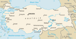
Turkey is situated in Anatolia (97%) and the Balkans (3%), bordering the Black Sea, between Bulgaria and Georgia, and bordering the Aegean Sea and the Mediterranean Sea, between Greece and Syria. The geographic coordinates of the country lie at: 39°00′N 35°00′E / 39.000°N 35.000°E
The area of Turkey is 783,562 km2 (302,535 sq mi);land: 770,760 km2 (297,592 sq mi), water: 9,820 km2 (3,792 sq mi).
Turkey extends more than 1,600 km (994 mi) from west to east but generally less than 800 km (497 mi) from north to south. The total area (of about 783,562 km2 (302,535 sq mi)) consists of about 756,816 km2 (292,208 sq mi) in Western Asia (Anatolia) and about 23,764 km2 (9,175 sq mi) in Southeastern Europe (Thrace).
Anatolia (Turkish: Anadolu) is a large, roughly rectangular peninsula, situated bridge-like between Europe and Asia. The Anatolian part of Turkey accounts for 97% of the country's area. It is also known as Asia Minor, Asiatic Turkey or the Anatolian Plateau. The term Anatolia is most frequently used in specific reference to the large, semiarid central plateau, which is rimmed by hills and mountains that in many places limit access to the fertile, densely settled coastal regions.
...
Wikipedia
