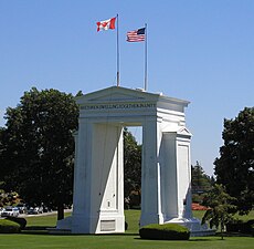
US-Canada border
| Canada–United States border | |
|---|---|

|
|
| Characteristics | |
| Entities | |
| Length | 8,891 km (5,525 mi) |
| History | |
| Established | September 3, 1783 |
| Signing of the Treaty of Paris at the end of the American War of Independence | |
| Current shape | April 11, 1908 |
| Treaty of 1908 | |
| Treaties | Treaty of Paris, Jay Treaty, Treaty of 1818, Webster–Ashburton Treaty, Oregon Treaty |
| Notes | See list of current disputes |
The Canada–United States border, officially known as the International Boundary, is the longest international border in the world between two countries. It is shared between Canada and the United States, the second- and fourth-largest countries by area, respectively. The terrestrial boundary (including portions of maritime boundaries in the Great Lakes, and on the Atlantic, Pacific, and Arctic coasts) is 8,891 kilometres (5,525 mi) long, of which 2,475 kilometres (1,538 mi) is Canada's border with Alaska. Eight Canadian provinces and territories (Yukon, British Columbia, Alberta, Saskatchewan, Manitoba, Ontario, Quebec, and New Brunswick), and thirteen U.S. states (Alaska, Washington, Idaho, Montana, North Dakota, Minnesota, Michigan, Ohio, Pennsylvania, New York, Vermont, New Hampshire, and Maine) are located along the border.
The Treaty of Paris of 1783 ended the American Revolutionary War between Great Britain and the United States. In the second article of the Treaty the parties agreed on all of the boundaries of the United States, including but not limited to the boundary with British North America to the north. The agreed boundary included the line from the northwest angle of Nova Scotia to the northwesternmost head of Connecticut River, and proceeded down along the middle of the river to the 45th parallel of north latitude.
...
Wikipedia
