Surrey, British Columbia
| Surrey | |||||||
|---|---|---|---|---|---|---|---|
| City | |||||||
| City of Surrey | |||||||
|
|||||||
|
|||||||
| Nickname(s): City of Parks | |||||||
| Motto: "The future lives here" | |||||||
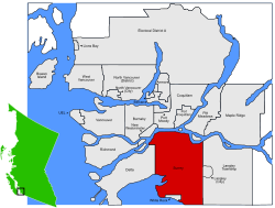 Location of Surrey |
|||||||
| Coordinates: 49°11′N 122°51′W / 49.183°N 122.850°WCoordinates: 49°11′N 122°51′W / 49.183°N 122.850°W | |||||||
| Country | Canada | ||||||
| Province | British Columbia | ||||||
| Regional District | Metro Vancouver | ||||||
| Incorporation | 1879 (municipality status) | ||||||
| 1993 (city status) | |||||||
| Government | |||||||
| • Mayor | Linda Hepner | ||||||
| • City Council |
List of Councillors
|
||||||
| • MLAs |
List of MLAs
|
||||||
| • MPs |
List of MPs
|
||||||
| • School Trustees |
List of Trustees
|
||||||
| Area | |||||||
| • Total | 316.41 km2 (122.17 sq mi) | ||||||
| Highest elevation | 134 m (440 ft) | ||||||
| Lowest elevation | 0 m (0 ft) | ||||||
| Population (2014) | |||||||
| • Total | 508,404 | ||||||
| • Rank | 12th | ||||||
| • Density | 1,600/km2 (4,200/sq mi) | ||||||
| Demonym(s) | Surreyite | ||||||
| Time zone | PST (UTC-08) | ||||||
| • Summer (DST) | PDT (UTC-07) | ||||||
| Postal code span | V3R–V3X, V3Z, V4A, V4N, V4P | ||||||
| Area code(s) | 604, 778, 236 | ||||||
| Highways |
|
||||||
| Website | www |
||||||
Surrey is a city in the province of British Columbia, Canada. It is a member municipality of the Metro Vancouver regional district and metropolitan area. Mainly a suburban city, Surrey is the province's third largest city by area, after Abbotsford and Prince George, and the second-largest city by population after the city of Vancouver.
The six "town centres" the City of Surrey comprises are: Fleetwood, Whalley/City Centre, Guildford, Newton, Cloverdale, and South Surrey.
Surrey became incorporated in 1879, and encompasses land formerly occupied by a number of Halqemeylem-speaking aboriginal groups. When Englishman H.J. Brewer looked across the Fraser River from New Westminster and saw a land reminiscent of his native County of Surrey in England, the settlement of Surrey was placed on the map. The area then comprised forests of douglas-fir, fir, red cedar, hemlock, blackberry bushes, and cranberry bogs. A portion of present-day Whalley (named after Harry Whalley, who owned and operated a gas bar at the bend in King George Blvd, (formerly King George Highway) at 108 Avenue, "Whalley's Corner") was used as a burial ground by the Kwantlen (or Qw’ontl’en) Nation.
...
Wikipedia


