Fraser River
The Fraser River /ˈfreɪzər/ is the longest river within British Columbia, Canada, rising at Fraser Pass near Blackrock Mountain in the Rocky Mountains and flowing for 1,375 kilometres (854 mi), into the Strait of Georgia at the city of Vancouver. It is the 10th longest river in Canada. The river's annual discharge at its mouth is 112 cubic kilometres (27 cu mi) or 3,550 cubic metres per second (125,000 cu ft/s), and it discharges 20 million tons of sediment into the ocean. The river is named for Simon Fraser, who led an expedition on behalf of the North West Company from the site of present-day Prince George almost to the mouth of the river. The river's name in the Halqemeylem (Upriver Halkomelem) language is Sto:lo, often seen archaically as Staulo, and has been adopted by the Halkomelem-speaking peoples of the Lower Mainland as their collective name, Sto:lo. The river's name in the Dakelh language is Lhtakoh. The Tsilhqot'in name for the river, not dissimilar to the Dakelh name, is ʔElhdaqox, meaning Sturgeon (ʔElhdachogh) River (Yeqox).
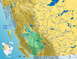
The Fraser drains a 220,000-square-kilometre (85,000 sq mi) area. Its source is a dripping spring at Fraser Pass. The river then flows north to the Yellowhead Highway and west past Mount Robson to the Rocky Mountain Trench and the Robson Valley near Valemount. After running northwest past 54° north, it makes a sharp turn to the south at Giscome Portage, meeting the Nechako River at the city of Prince George, then continuing south, progressively cutting deeper into the Fraser Plateau to form the Fraser Canyon from roughly the confluence of the Chilcotin River, near the city of Williams Lake, southwards. It is joined by the Bridge and Seton Rivers at the town of Lillooet, then by the Thompson River at Lytton, where it proceeds south until it is approximately 64 kilometres (40 mi) north of the 49th parallel, which is Canada's border with the United States.
...
Wikipedia


