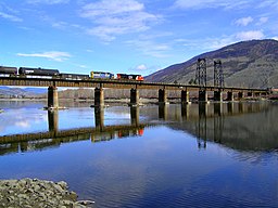
Thompson River
| Thompson River | |
| River | |
| Country | Canada |
|---|---|
| Province | British Columbia |
| Source | Confluence of the North & South Thompson Rivers |
| - location | Kamloops |
| - elevation | 1,113 m (3,652 ft) |
| - coordinates | 50°40′49″N 120°20′36″W / 50.68028°N 120.34333°W |
| Mouth | Fraser River |
| - location | Lytton |
| - elevation | 472 m (1,549 ft) |
| - coordinates | 50°14′07″N 121°35′00″W / 50.23528°N 121.58333°WCoordinates: 50°14′07″N 121°35′00″W / 50.23528°N 121.58333°W |
| Length | 489 km (304 mi) |
| Basin | 56,000 km2 (21,622 sq mi) |
| Discharge | for Spences Bridge |
| - average | 773 m3/s (27,300 cu ft/s) |
| - max | 4,200 m3/s (148,000 cu ft/s) |
| - min | 171 m3/s (6,039 cu ft/s) |
|
A map of the Thompson River's watershed
|
|
The Thompson River is the largest tributary of the Fraser River, flowing through the south-central portion of British Columbia, Canada. The Thompson River has two main branches, the South Thompson River and the North Thompson River. The river is home to several varieties of Pacific salmon and trout. The area's geological history was heavily influenced by glaciation, and the several large glacial lakes have filled the river valley over the last 12,000 years. Archaeological evidence shows human habitation in the watershed dating back to at least 8300 years. The Thompson was named by Fraser River explorer, Simon Fraser, in honour of his friend, Columbia Basin explorer David Thompson. Recreational use of the river includes whitewater rafting and angling.
The South Thompson originates at the outlet of Little Shuswap Lake at the town of Chase and flows approximately 55 kilometres (34 mi) southwest through a wide valley to Kamloops where it joins the North Thompson. Highway 1, the Trans-Canada Highway and the mainline of the Canadian Pacific Railway parallel the river. Little Shuswap Lake is fed by the Little River, which drains Shuswap Lake, which is fed by several rivers & creeks.
The North Thompson originates at the toe of the Thompson Glacier in the Cariboo Mountains west of the community of Valemount and flows generally south towards Kamloops and the confluence with the South Thompson. For most of its length, the river is paralleled by Highway 5, and the Canadian National Railway (both of which cross the river a couple times). The North Thompson passes by several small communities, the most notable being Blue River, Clearwater & Barriere.
...
Wikipedia


