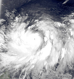
Typhoon Muifa (2011)
| Typhoon (JMA scale) | |
|---|---|
| Category 5 (Saffir–Simpson scale) | |

Typhoon Muifa at peak strength on July 30
|
|
| Formed | July 27, 2011 |
| Dissipated | August 15, 2011 |
| (Extratropical after 9 August) | |
| Highest winds |
10-minute sustained: 175 km/h (110 mph) 1-minute sustained: 260 km/h (160 mph) |
| Lowest pressure | 930 hPa (mbar); 27.46 inHg |
| Fatalities | 22 dead; 42 injured; 6 missing |
| Damage | $480 million (2011 USD) |
| Areas affected | Micronesia, Philippines, Taiwan, Japan, China, South Korea, North Korea, Russia |
| Part of the 2011 Pacific typhoon season | |
Typhoon Muifa, known in the Philippines as Typhoon Kabayan, was a large, powerful and persistent typhoon which affected a number of countries in the Pacific, killing 22 and causing widespread damage worth US$480 million. It was the ninth named storm, third typhoon and the second super-typhoon of the 2011 Pacific typhoon season.
The low-pressure area which became Typhoon Muifa originally formed on July 23. It gradually drifted to the west, becoming a tropical depression. As it turned north and neared the Philippines it rapidly strengthened, becoming a Category 5 typhoon on the Saffir-Simpson Hurricane Scale (SSHS). In the Philippines, the storm claimed eight lives and caused much damage. The system brought down trees; the northeast Philippines experienced strong winds and heavy rains, leaving motorists stranded on several roads and expressways. Muifa also sank a Malay ship with 178 passengers. The system then drifted north, weakening steadily until it curved to the west and threatened Micronesia. The typhoon hit Okinawa, Japan with 41 inches of rain, flooding the small island and injuring 37 people in a 30-hour period. The storm disrupted air travel, leaving 13,630 people stranded on the island. The system then steadily drifted west, nearing Taiwan and prompting emergency warnings and high alerts; however, the storm missed the island. The typhoon moved further west towards mainland China, causing thousands to flee from their homes. A level-4 high-wave warning was issued, and some 11,000 rescue workers mobilized in 120 teams.
A parade of low-pressure areas and tropical disturbances formed from the Intertropical Convergence Zone late on July 15. Late on July 23, one of the last low-pressure systems developed further to a weak tropical disturbance, which formed southeast of Chuuk in Micronesia. The system drifted to the west, and on July 25 the Joint Typhoon Warning Center (JTWC) upgraded the low-pressure area to a tropical depression. At that time, it was located approximately 505 nautical miles (935 km; 581 mi) west of Guam. At midnight that day, the JMA began monitoring the system as a tropical depression.
...
Wikipedia
