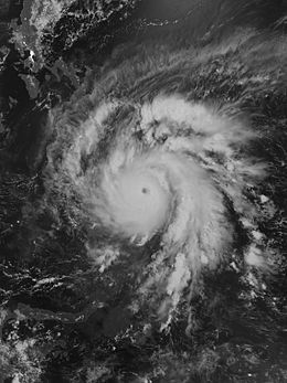
Typhoon Bopha
| Typhoon (JMA scale) | |
|---|---|
| Category 5 (Saffir–Simpson scale) | |

Typhoon Bopha at peak intensity near Mindanao on December 3
|
|
| Formed | November 25, 2012 |
| Dissipated | December 9, 2012 |
| Highest winds |
10-minute sustained: 185 km/h (115 mph) 1-minute sustained: 280 km/h (175 mph) |
| Lowest pressure | 930 hPa (mbar); 27.46 inHg |
| Fatalities | 1,067 total, 834 missing |
| Damage | $1.04 billion (USD) |
| Areas affected | Federated States of Micronesia, Palau, Philippines |
| Part of the 2012 Pacific typhoon season | |
| Costliest Philippine typhoons | ||||
|---|---|---|---|---|
|
|
||||
| Rank | Name | Year | PHP | USD |
| 1 | Haiyan (Yolanda) | 2013 | 89.6 billion | 2.02 billion |
| 2 | Bopha (Pablo) | 2012 | 42.2 billion | 1.04 billion |
| 3 | Rammasun (Glenda) | 2014 | 38.6 billion | 871 million |
| 4 | Parma (Pepeng) | 2009 | 27.3 billion | 608 million |
| 5 | Nesat (Pedring) | 2011 | 15 billion | 333 million |
| 6 | Fengshen (Frank) | 2008 | 13.5 billion | 301 million |
| 7 | Koppu (Lando) | 2015 | 11 billion | 236 million |
| 8 | Megi (Juan) | 2010 | 11 billion | 255 million |
| 9 | Ketsana (Ondoy) | 2009 | 11 billion | 244 million |
| 10 | Mike (Ruping) | 1990 | 10.8 billion | 241 million |
|
|
||||
|
||||
| Deadliest Philippine typhoons | |||
|---|---|---|---|
|
|
|||
| Rank | Typhoon | Year | Deaths |
| 1 | September 1881 Typhoon | 1881 | 20,000 |
| 2 | Haiyan (Yolanda) | 2013 | 6,300 |
| 3 | Thelma (Uring) | 1991 | 5,100 |
| 4 | Bopha (Pablo) | 2012 | 1,901 |
| 5 | "Angela Typhoon" | 1867 | 1,800 |
| 6 | Winnie | 2004 | 1,619 |
| 7 | October 1897 Typhoon | 1897 | 1,500 |
| 8 | Ike (Nitang) | 1984 | 1,363 |
| 9 | Washi (Sendong) | 2011 | 1,268 |
| 10 | Trix | 1952 | 995 |
|
|
|||
|
|||
Typhoon Bopha, known in the Philippines as Typhoon Pablo, was the strongest tropical cyclone to ever hit the southern Philippine island of Mindanao, making landfall as a Category 5 super typhoon with winds of 175 mph (280 km/h). Bopha originated unusually close to the equator, becoming the second-most southerly Category 5 super typhoon, reaching a minimum latitude of 7.4°N on December 3, 2012. Only Typhoon Louise of 1964 came closer to the equator at this strength, at 7.3°N. After first hitting Palau, where it destroyed houses, disrupted communications and caused power outages, flooding and uprooted trees, Bopha made landfall late on December 3 on Mindanao, an island that had been devastated by the much weaker Tropical Storm Washi in December 2011. The storm caused widespread destruction on Mindanao, leaving thousands of people homeless and more than 600 fatalities.
After hitting Davao Oriental and Compostela Valley provinces, Typhoon Bopha crossed the southern and central regions of Mindanao, cutting power to two provinces and triggering landslides. More than 170,000 people fled to evacuation centers. The typhoon moved to the South China Sea west of the Palawan island province, eventually dissipating on December 9.
On November 23, 2012, a large area of convection persisted 650 km (400 mi) south of Pohnpei, near the equator at a latitude of 0.6ºN. The system had a poorly defined, elongated atmospheric circulation and was located in an area of moderate wind shear and restricted outflow, due to a subtropical ridge to the north. As a result, the Joint Typhoon Warning Center (JTWC) assessed a low chance for tropical cyclogenesis. The center slowly consolidated, with a well-defined mid-level . Late on November 25, the JTWC issued a tropical cyclone formation alert after it organized further, noting that the system had developed an anticyclone which was providing outflow. Around the same time, the Japan Meteorological Agency (JMA) classified the system as a tropical depression, about 410 km (255 mi) south-southwest of Pohnpei. At 2100 UTC on November 25, the JTWC also upgraded the system to Tropical Depression 26W.
...
Wikipedia
