Simele
|
Simele ܫܡܐܝܠ سميل Shem'ēl |
|
|---|---|

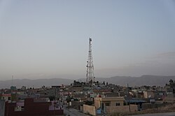
Simele in 2012
|
|
| Location in Iraq | |
| Coordinates: 36°51′30″N 42°51′0.35″E / 36.85833°N 42.8500972°ECoordinates: 36°51′30″N 42°51′0.35″E / 36.85833°N 42.8500972°E | |
| Country |
|
| Autonomous region |
|
| Governorate | Dohuk Governorate |
| Population | 50,000 |
Simele (Syriac: Šhem'ēl ܫܡܐܝܠ, Kurdish: Sêmêl, Arabic:سميل) is a town located in the Dohuk province of Iraqi Kurdistan. The city is on the main road that connects Iraq to its neighbour Turkey. It is 14 km west of the city of Dohuk. Today it has a mixed population of Kurds, Assyrians, Yazidis and Armenians.
The town was mentioned by Yaqut al-Hamawi as "Simwel" which is thought to be a corruption of the Syriac Simmālā (ܣܡܠܐ) meaning "left". Another possible origin could be the Syriac Shemʻēl (ܫܡܥ ܐܝܠ), which means "the name of God".
Historically, the region in which Simele lies was a part of Assyria during its existence as a nation and then province from the 24th century BCE until the 7th century AD. The town was converted to Christianity in the 2nd century and was later famous for its Syriac manuscripts. Its Assyrian inhabitants were belonged to both the Syriac Orthodox Church and the Assyrian Church of the East. Its Assyrians inhabitants were joined by Yazidis who settled the town in 1800. Both were in turn massacred by Mir Muhammad of Rowanduz. Later on, Arab tribes also started settling the area.
Simele, in the early 20th century, was a very small Kurdish village. A significant Assyrian community reformed in the town during World War I in the wake of the mass migration from the Hakkari region of Turkey, due to the Assyrian Genocide by the Ottoman Empire against native Armenians and Assyrians.
...
Wikipedia

