Rochdale (ancient parish)
| Rochdale | |
|---|---|
 Church of St Chad, Rochdale |
|
 |
|
| Area | |
| • 1831 | 58,620 acres (237.2 km2) |
| • 1861 | 40,340 acres (163.3 km2) |
| • Coordinates | 53°36′53″N 2°09′28″W / 53.6147°N 2.1577°WCoordinates: 53°36′53″N 2°09′28″W / 53.6147°N 2.1577°W |
| Population | |
| • 1801 | 26,577 |
| • 1861 | 91,754 |
| History | |
| • Created | Early Middle Ages |
| Status | Ecclesiastical parish |
| • HQ | Rochdale |
| Subdivisions | |
| • Type | Townships |
| • Units |
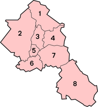
1. Todmorden and Walsden 2. Spotland 3. Wuerdle and Wardle 4. Blatchinworth and Calderbrook 5. Wardleworth 6. Castleton 7. Butterworth 8. Saddleworth |
 |
|
1. Todmorden and Walsden 2. Spotland 3. Wuerdle and Wardle 4. Blatchinworth and Calderbrook 5. Wardleworth 6. Castleton 7. Butterworth
Rochdale was an ecclesiastical parish of early-medieval origin in northern England, administered from the Church of St Chad, Rochdale. At its zenith, it occupied 58,620 acres (237 km2) of land amongst the South Pennines, and straddled the historic county boundary between Lancashire and the West Riding of Yorkshire. To the north and north-west was the parish of Whalley; to the southwest was the parish of Bury; to the south was Middleton and Prestwich-cum-Oldham.
Anciently a dependency of Whalley Abbey, the parish of Rochdale is believed to be of Anglo-Saxon origin, as evidenced by historical documentation, toponymy and its dedication to Chad of Mercia.
Urbanisation, population shifts, and local government reforms all contributed towards the gradual alteration and ultimate dissolution of the historic parish boundaries; the social welfare functions of the parish were broadly superseded by the English Poor Laws and new units of local governance, such as the County Borough of Rochdale and the Milnrow Urban District. Today, the territory of the former parish lies within Lancashire, Greater Manchester and West Yorkshire.
...
Wikipedia
