West Riding of Yorkshire
| County of York, West Riding | |
|---|---|
 Flag of West Riding (2013) |
|
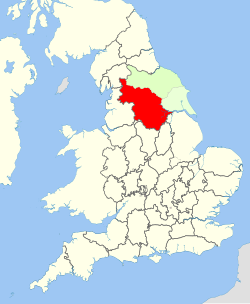
 West Riding shown within England |
|
| Area | |
| • 1911 | 1,685,409 acres (6,820.61 km2) |
| • 1961 | 1,621,068 acres (6,560.23 km2) |
| Population | |
| • 1901 | 1,538,572 |
| • 1971 | 1,924,853 |
| History | |
| • Created | Historic Riding - AD889 Administrative county - 1889 |
| • Abolished | Historic Riding - not abolished Administrative county - 1974 |
| • Succeeded by |
West Yorkshire South Yorkshire North Yorkshire Lancashire Cumbria Greater Manchester Humberside |
| Status |
Ancient Riding, then Administrative county |
| Chapman code | WRY |
| • HQ | Wakefield |
| • Motto | Audi consilium (Heed Counsel) |
 Coat of arms of West Riding County Council |
|
The West Riding of Yorkshire is one of the three historic subdivisions of Yorkshire, England. From 1889 to 1974 the administrative county, County of York, West Riding (abbreviated: "County of York (W.R.)") (the area under the control of West Riding County Council), was based closely on the historic boundaries. The lieutenancy at that time included the City of York and as such was named West Riding of the County of York and the County of the City of York.
Its boundaries roughly correspond to the present ceremonial counties of West Yorkshire, South Yorkshire and the Craven, Harrogate and Selby districts of North Yorkshire, along with smaller parts in Lancashire (for example, the parishes of Bracewell, Brogden and Salterforth became part of the Pendle district of Lancashire and the parishes of Great Mitton, Newsholme and Bowland Forest Low became part of the Ribble Valley district also in Lancashire), Cumbria, Greater Manchester and, since 1996, the unitary East Riding of Yorkshire.
The West Riding encompasses 1,771,562 acres (7,169 km²) from Sheffield in the south to Sedbergh in the north and from Dunsop Bridge in the west to Adlingfleet in the east.
...
Wikipedia
