Butterworth (ancient township)
| Butterworth | |
|---|---|
 A boundary stone on the A663 road, marking the ancient border between Butterworth and Crompton |
|
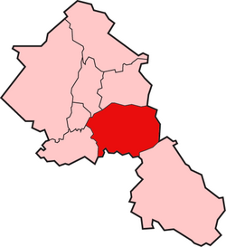
 Butterworth shown within the parish of Rochdale |
|
| Area | |
| • 1871 | 7,766 acres (31.43 km2) |
| • 1891 | 7,766 acres (31.43 km2) |
| History | |
| • Created | Middle Ages |
| • Abolished | 1894 |
| Status |
Township (1148 - 1894) & Civil Parish (1866 - 1894) |
| • Units | Butterworth Freehold, Butterworth Lordship |
Butterworth was a township occupying the southeastern part of the parish of Rochdale, in the hundred of Salford, Lancashire, England. It encompassed 12.1 square miles (31 km2) of land in the South Pennines which spanned the settlements of Belfield, Bleaked-gate-cum-Roughbank, Butterworth Hall, Clegg, Haughs, Hollingworth, Kitcliffe, Lowhouse, Milnrow, Newhey, Ogden, Rakewood, Smithy Bridge, Tunshill and Wildhouse. It extended to the borders of Crompton to the south, and to the highest points of Bleakedgate Moor and Clegg Moor, up to the ridge of Blackstone Edge, to the east, where its boundary was the old county boundary between Lancashire and Yorkshire.
Butterworth was probably settled in Saxon times in the Early Middle Ages. Its land was divided into two divisions — the Lordship side with rents or services payable to the lord of the manor and the Freehold side that retained its importance until 1879 as a Registration district for births, deaths and marriages. In 1830, Butterworth was recorded to have 5,554 inhabitants.
Butterworth probably originates from the Anglo-Saxon settlement of England in the early Middle Ages. Its name is derived from the Old English butere meaning butter and worð meaning an enclosure. Butterworth was one of four divisions of the ancient parish of Rochdale in the Salford Hundred. Its recorded history dates from the mid-12th century. The Order of St John of Jerusalem, the Knights Hospitaller, had extensive land holdings, and whose practice was to mark the boundaries of their lands and buildings where rents were due by a stone or metal cross. In 1851 an old half-timbered house at Butterworth Hall hamlet was destroyed by fire revealing an iron cross at its gable, indicating it was owned by the order until the dissolution of the monasteries in 1536-1539 by Henry VIII. A charter of 1244, mentioned land in Butterworth adjoining land belonging to Sir Baldwin Teutonicas (or de Tyas) who was a knight of the order. A charter of about 1280 transferred rents amounting to twopence in silver and four barbed arrows of iron for lands in Butterworth to the Abbot of Stanlow Abbey. The name of the township was used by Reginal(d) de Boterworth, lord of the manor who was granted land in the township by a charter of 1148. Butterworth Hall was built before 1166. A manuscript from the reign of Edward II recorded the township's name as Buckworth
...
Wikipedia
