Castleton, Greater Manchester
| Castleton | |
|---|---|
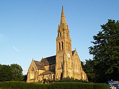
 St Martin's has dominated Castleton's skyline since 1863 |
|
| Castleton shown within Greater Manchester | |
| Population | 10,159 (2011 Census) |
| OS grid reference | SD8810 |
| • London | 168 mi (270 km) SSE |
| Metropolitan borough | |
| Metropolitan county | |
| Region | |
| Country | England |
| Sovereign state | United Kingdom |
| Post town | ROCHDALE |
| Postcode district | OL11 |
| Dialling code | 01706 |
| Police | Greater Manchester |
| Fire | Greater Manchester |
| Ambulance | North West |
| EU Parliament | North West England |
| UK Parliament | |
Castleton is an area of Rochdale, Greater Manchester, England, 1.2 miles (1.9 km) south-southwest of Rochdale town centre and 8 miles (13 km) north-northeast of the city of Manchester.
Historically a part of Lancashire, Castleton's early history is marked by its status as a township within the ancient parish of Rochdale. Prior to merging with the County Borough of Rochdale in 1900, Castleton experienced rapid growth during the 19th century as a mill town in its own right, facilitated for the most part by the construction of the Rochdale Canal which is routed through the area. Castleton's growth was significant; so much so, that for a time it was almost the same size of nearby Rochdale.
Located between junctions 19 and 20 of the M62 motorway, Castleton today is a predominantly residential area, with a total population of 9,715, increasing to 10,159 at the 2011 Census.
The most ancient known reference to Castleton is found in the Domesday Book (1086). The name suggests a link with a fortification; the Castleton area was the site of Rochdale Castle. The castle is believed to have been located on the south bank of the River Roch, which runs through Castleton.
During the 13th century, Castleton was known as Castletown, or Castle Town.
Back around the time the canal was built, Castleton was known as Blue Pits Village, because of the blue clay that was found and mined around the area that the railway is now. This information is on a tourist sign on the entrance to the canal off the Manchester bound side of Manchester Road.
The Rochdale Canal was routed through Castleton around the year 1800 and made Castleton one of the larger industrial areas in North West England. The canal granted jobs for hundreds of local residents, as it enabled the construction of several cotton mills. With the mills came the need for engineering and from 1892, Castleton was the home of Tweedales and Smalley who manufactured looms and textile machinery. Their 14 acres (5.7 ha) Globe Works factory no longer exists, being part of the Woolworth's site.
...
Wikipedia

