Regional Municipality of Waterloo, Ontario
| Waterloo Region | ||
|---|---|---|
| Upper-tier regional municipality | ||
| Regional Municipality of Waterloo | ||
|
||
| Motto: "Peace, Prosperity!" | ||
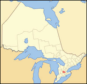
 Location of Waterloo Region in Ontario |
||
| Coordinates: 43°28′N 80°30′W / 43.467°N 80.500°WCoordinates: 43°28′N 80°30′W / 43.467°N 80.500°W | ||
| Country |
|
|
| Province |
|
|
| Government | ||
| • Regional Chair | Ken Seiling | |
| • Governing Body | Waterloo Regional Council | |
| • MPs |
List of MPs
|
|
| • MPPs |
List of MPPs
|
|
| Area | ||
| • Land | 1,368.94 km2 (528.55 sq mi) | |
| Population (2011) | ||
| • Total | 507,096 | |
| • Density | 370.4/km2 (959/sq mi) | |
| Time zone | EST (UTC−5) | |
| • Summer (DST) | EDT (UTC−4) | |
| Area code(s) | (519) and (226) | |
| Website | region |
|
The Regional Municipality of Waterloo is a regional municipality located in Southern Ontario, Canada. It consists of the cities of Kitchener, Cambridge, and Waterloo (collectively called the Tri-Cities), and the townships of Wellesley, Woolwich, Wilmot, and North Dumfries. It is often referred to as the Region of Waterloo or just Waterloo Region. The Region is 1,369 square kilometres in size and its regional seat of government is in Kitchener. The Region's population was 507,096 at the 2011 census.
During the 16th and 17th centuries, the area was inhabited by the Iroquoian speaking Attawandaron nation.
Historical accounts differ on exactly how the Attawandaron tribe was wiped out, but it is generally agreed that the Seneca and the Mohawk tribes of the Six Nations destroyed or forced out the smaller Attawandaron tribe while severely crippling the Huron around 1680-85. After the invasion of the Six Nations into the Grand River Valley, the Neutral tribe ceased to have any political existence. Any dispersed survivors were taken captive or escaped to other tribes such as the Mississaugas and were assimilated into that culture. There are no distinct Attawandarons today.
In 1784, the British government granted the Grand River Valley to the Iroquois, who had supported the Loyalists in the American War of Independence, to compensate them for the loss of their land in New York. The Iroquois settled in the lower Grand River Valley (now The County of Brant), and sold parts of the land which was part of Waterloo Township to Colonel Richard Beasley, a United Empire Loyalist. Another developer was William Dickson who, in 1816, came into sole possession of 90,000 acres (360 km2) of land along the Grand River that was later to make up North and South Dumfries Townships.
...
Wikipedia

