Grand River (Ontario)
| Grand River | |
|---|---|

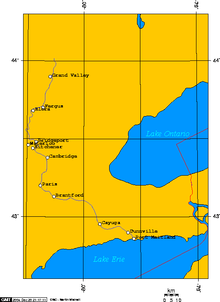
A map of the Grand River's course
|
|
| Country | Canada |
| Basin | |
| Main source | Near Dundalk, Ontario 525 m (1,722 ft) |
| River mouth |
Lake Erie at Port Maitland 174 m (571 ft) |
| Physical characteristics | |
| Length | 280 km (170 mi) |
The Grand River (Grande-Riviere in French and O:se Kenhionhata:tie in Mohawk) is a large river in Southwestern Ontario, Canada. It also lies along the western fringe of the Golden Horseshoe region of Ontario which overlaps the southwestern region of the province along the length of this river. From its source near Wareham, Ontario, it flows south through Grand Valley, Fergus, Elora, Waterloo, Kitchener, Cambridge, Paris, Brantford, Caledonia, and Cayuga before emptying into the north shore of Lake Erie south of Dunnville at Port Maitland. One of the scenic and spectacular features of the river is the falls and Gorge at Elora.
The Grand River is the largest river that is entirely within southern Ontario's boundaries. The river owes its size to the unusual fact that its source is relatively close to the base of the Bruce Peninsula, yet it flows southwards to Lake Erie, rather than to central Lake Huron or Georgian Bay (most southern Ontario rivers flow into the nearest Great Lake, which is why most of them are small), thus giving it more distance to take in more water from tributaries.
...
Wikipedia
