Southwestern Ontario
| Southwestern Ontario | |
|---|---|
| Secondary region | |
 |
|
| Coordinates: 43°30′N 81°00′W / 43.500°N 81.000°WCoordinates: 43°30′N 81°00′W / 43.500°N 81.000°W | |
| Country |
|
| Province |
|
| Area | |
| • Total | 36,746 km2 (14,188 sq mi) |
| Population (2006) | |
| • Total | 3,443,484 |
| • Density | 94/km2 (240/sq mi) |
| Time zone | EST (UTC−5) |
| • Summer (DST) | EDT (UTC−4) |
| Postal code prefixes | N |
| Area code(s) | 519, 226, 905, 289 |
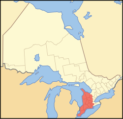
Southwestern Ontario is a secondary region of Southern Ontario in the Canadian province of Ontario, centered on the city of London. It occupies most of a peninsula that is bound on three sides by water: Lake Huron, including Georgian Bay, to the north and northwest; the St. Clair River, Lake St. Clair, and Detroit River, to the west; and Lake Erie to the south. To the east, on land, Southwestern Ontario is bounded by Central Ontario and the Golden Horseshoe. The region had a population of 2,504,878 in 2011.
Apart from London, other towns and cities in the core area of Southwestern Ontario include Chatham, Ingersoll, Sarnia, St. Thomas, Tillsonburg, Windsor, and . Outside the core, cities located on or near the Grand River are also considered to be part of the extended Golden Horseshoe region that surrounds western Lake Ontario. They include Brantford, Cambridge, Guelph, Kitchener, and Waterloo.
Two subregions are recognisable with Southwestern Ontario. The Bruce Peninsula and Georgian Bay shoreline, including Owen Sound and the Blue Mountains, are also part of the Georgian Triangle. Cities and towns located more immediately north of London, including Stratford, Goderich, Wingham, Mount Forest, and Hanover, are considered part of the subregion of "Midwestern Ontario".
...
Wikipedia
