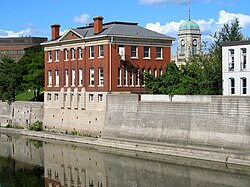
Cambridge, Ontario
| Cambridge | |||
|---|---|---|---|
| City (lower-tier) | |||
| City of Cambridge | |||
 |
|||
|
|||
| Nickname(s): The Bridge, The Tri-City | |||
| Motto: A fine place for business, a great place to call home. | |||
| Location of Cambridge in southern Ontario | |||
| Coordinates: 43°22′N 80°19′W / 43.367°N 80.317°WCoordinates: 43°22′N 80°19′W / 43.367°N 80.317°W | |||
| Country |
|
||
| Province |
|
||
| Region | Waterloo | ||
| Established | January 1973 | ||
| Government | |||
| • Mayor | Doug Craig | ||
| • Governing Body | Cambridge City Council | ||
| Area | |||
| • Land | 112.86 km2 (43.58 sq mi) | ||
| Elevation | 329 m (1,079 ft) | ||
| Population (2011) | |||
| • Total | 129,920 (Ranked 38th) | ||
| • Density | 1,121.7/km2 (2,905/sq mi) | ||
| Time zone | Eastern (EST) (UTC−5) | ||
| Postal code span | N1(P-T); N3(C-H) | ||
| Area code(s) | 519 and 226 | ||
| Highways |
|
||
| Website | www.cambridge.ca | ||
Cambridge (2016 population 131,794) is a city located in Southern Ontario at the confluence of the Grand and Speed rivers in the Regional Municipality of Waterloo, Ontario, Canada. It is an amalgamation of the City of Galt, the towns of Preston and Hespeler, and the hamlet of Blair. Galt covers the largest portion of Cambridge, making up the southern half of the city. Preston and Blair are located on the western side of the city, while Hespeler is in the most northeasterly section of Cambridge.
Cambridge began as a composite city in 1973, when the City of Galt, Towns of Preston and Hespeler, and the hamlet of Blair were amalgamated.
There was considerable resistance among the local population to this "shotgun marriage" arranged by the provincial government and a healthy sense of rivalry had always governed relations among the three communities. Even today, though many residents will tell the outside world that they call Cambridge home, they will often identify themselves to each other as citizens of Galt or Preston or Hespeler. Each unique centre has its own history that is well documented in the Cambridge City Archives.
The first mayor of Cambridge was Claudette Millar, who at the time was one of the few female mayors and, at 35, the youngest mayor in Canada.
As Cambridge has developed and the open spaces between the original municipalities have been filled in, a fourth commercial core, entirely modern in its construction, has emerged. The Macdonald-Cartier Freeway Highway 401 runs through its midst.
On May 17, 1974, flooding on the Grand River was so intense it filled city streets with water to a depth of about four feet. Hundreds of businesses and homes were severely damaged.
In 1784 the British Crown granted to the Six Nations Indians, in perpetuity, all the land along the Grand River six miles (10 km) deep on each side of the river from its source to Lake Erie. The First Nations, led by Joseph Brant, had the land surveyed in 1791 and divided into Indian Reserve lands as well as large tracts which they intended to sell to land developers. One such developer was the Honourable William Dickson who, in 1816, came into sole possession of 90,000 acres (360 km2) of land along the Grand River that was later to make up North and South Dumfries Townships.
...
Wikipedia


