Highway 401
| Highway 401 | ||||
|---|---|---|---|---|
| Macdonald–Cartier Freeway | ||||

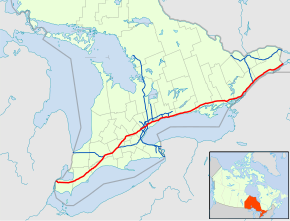
Highway 401 within Southern Ontario
|
||||
| Route information | ||||
| Maintained by the Ministry of Transportation of Ontario | ||||
| Length: | 828.0 km (514.5 mi) | |||
| History: |
|
|||
| Major junctions | ||||
| West end: | Ojibway Parkway in Windsor | |||
|
||||
| East end: |
|
|||
| Location | ||||
| Major cities: | Windsor, London, Kitchener, Cambridge, Mississauga, Toronto, Oshawa, Kingston and Cornwall | |||
| Highway system | ||||
|
||||
![]() Highway 407 near Milton
Highway 407 near Milton
King's Highway 401, commonly referred to as Highway 401 and also known by its official name as the Macdonald–Cartier Freeway or colloquially as the four-oh-one, is a 400-series highway in the Canadian province of Ontario. It stretches 828.0 kilometres (514.5 mi) from Windsor in the west to the Ontario–Quebec border in the east. The part of Highway 401 that passes through Toronto is North America's busiest highway, and one of the widest. Together with Quebec Autoroute 20, it forms the road transportation backbone of the Quebec City–Windsor Corridor, along which over half of Canada's population resides and is also a Core Route in the National Highway System of Canada. The route is maintained by the Ministry of Transportation of Ontario (MTO) and patrolled by the Ontario Provincial Police. The speed limit is 100 km/h (62 mph) throughout its length, unless posted otherwise.
...
Wikipedia


