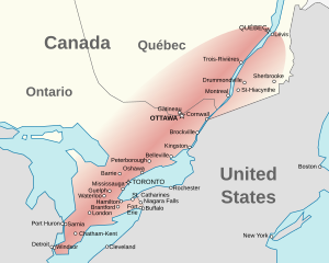
Quebec City–Windsor Corridor
| Quebec City–Windsor Corridor | |
|---|---|
| Region | |
 |
|
| Country |
|
| Province |
|
| Population (2011 est.) | |
| • Total | 18,420,000 |
| Time zone | EST (UTC−5) |
| • Summer (DST) | EDT (UTC−4) |
| Postal code prefixes | G, H, J, K, L, M, N |
| Area code(s) | 226, 289, 343, 365, 416, 418, 437, 438, 450, 514, 519, 579, 581, 613, 647, 705, 819, 873, 905 |
The Quebec City–Windsor Corridor is the most densely populated and heavily industrialized region of Canada. As its name suggests, the region extends between Quebec City in the northeast and Windsor, Ontario in the southwest, spanning 1,150 kilometres (710 mi). With more than 18 million people, it contains over half of the country's population and three of Canada's four largest metropolitan areas according to the 2011 Census. In its relative importance to Canada's economic and political infrastructure, it has many similarities to the Northeast megalopolis in the United States. The name was first popularized by Via Rail, which runs frequent passenger rail service in the Quebec City–Windsor Corridor in its service area known as "The Corridor".
The corridor extends from Quebec City, Quebec in the northeast to Windsor, Ontario in the southwest, running north of the Saint Lawrence River, Lake Ontario and Lake Erie. For most of its length, the corridor runs through a narrow strip of farmland with the Canadian Shield to the north and the Appalachian Mountains or the Great Lakes to the south. A drive of only a few minutes north from many of the corridor's cities or towns will show an abrupt change from flat farmland and limestone bedrock to the granite hills of the shield. The highways often run right on the boundary of the shield, and it is possible to observe the frequent change from limestone to granite in rockcuts along the way. There are, however, several wider areas of flat farmland, including the southwestern Ontario peninsula between Lake Huron and Lake Erie, the eastern Ontario delta from Ottawa to the junction of the Ottawa and St. Lawrence Rivers at Montreal, and the Eastern Townships southeast of Montreal. There is also a minor Great Lakes corridor of stratified limestone called the Niagara Escarpment.
...
Wikipedia
