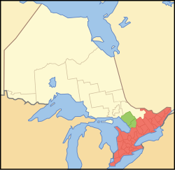
Southern Ontario
| Southern Ontario | |
|---|---|
| Primary region | |
 ██ Core area ██ Extended area |
|
| Coordinates: 44°00′N 80°00′W / 44.000°N 80.000°WCoordinates: 44°00′N 80°00′W / 44.000°N 80.000°W | |
| Country |
|
| Province |
|
| Area | |
| • Total | 139,931 km2 (52,860 sq mi) |
| • Core area | 126,819 km2 (48,565 sq mi) |
| • Extended area | 13,112 km2 (5,062 sq mi) |
| Population (2011) | |
| • Total | 12,118,805 |
| • Density | 86.4/km2 (224/sq mi) |
| • Core area | 12,018,596 |
| • Extended area | 100,209 |
| Time zone | EST (UTC−5) |
| • Summer (DST) | EDT (UTC−4) |
| Postal code prefixes | K, L, M, N |
| Area code(s) | 226, 289, 343, 416, 519, 613, 647, 705, 905 |
Southern Ontario is a primary region of the province of Ontario, Canada, the other primary region being Northern Ontario. It is the most densely populated and southernmost region in Canada. Situated south of Algonquin Park, it covers between 14 and 15% of the province, depending on the inclusion of the Parry Sound and Muskoka districts. The region is home to one-third of Canada's population.
Southern Ontario differs greatly from Northern Ontario, in that it has a larger population, different climate, and different culture than its northern counterpart. It is broken into smaller subregions, including Central Ontario, Eastern Ontario, Southwestern Ontario, and the Golden Horseshoe.
Southern Ontario is part of the Quebec City–Windsor Corridor, which extends northeast into Quebec.
Southern Ontario can be distinguished from Northern Ontario because it is far more densely populated and contains the majority of the province's cities, major roads, and institutions. Northern Ontario, in contrast, contains more natural resources and remote wilderness. Although it has no saltwater coastline, the region has an abundance of freshwater coastlines on three Great Lakes (Huron, Erie and Ontario), as well as smaller lakes such as Lake Simcoe and Lake St. Clair. It is a major vineyard region and producer of Canadian wines.
...
Wikipedia
