Ras Doumeira
| 2008 Djiboutian–Eritrean border conflict | |||||||
|---|---|---|---|---|---|---|---|
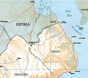
 Map of the Djibouti–Eritrea border |
|||||||
|
|||||||
| Belligerents | |||||||
|
|
Supported by: |
||||||
| Commanders and leaders | |||||||
|
|
|
||||||
| Casualties and losses | |||||||
| 100 killed 267 captured 21 defected |
44 killed 55 wounded 19 captured |
||||||
|
a Logistical, medical and intelligence support only. b No official figures from Eritrean sources. |
|||||||
a Logistical, medical and intelligence support only.
The Djiboutian–Eritrean border conflict between the forces of Djibouti and Eritrea occurred between June 10 and June 13, 2008. It was triggered by tension which began on April 16, 2008, when Djibouti reported that Eritrean armed forces had penetrated into Djiboutian territory and dug trenches on both sides of the border. The crisis deepened when armed clashes broke out between the two armed forces in the border area on June 10, 2008. During the conflict, France provided logistical, medical and intelligence support to Djibouti, but did not participate in direct combat.
The currently in force 1900 boundary agreement specifies that the international boundary starts at Cape Doumeira (Ras Doumeira) at the Red Sea and runs for 1.5 km along the watershed divide of the peninsula. Furthermore, the 1900 protocol specified that Ile Doumeira (Doumeira Island) immediately offshore and its adjacent smaller islets would not be assigned sovereignty and would remain demilitarized. Djibouti and Eritrea had twice previously clashed over the border area. In January 1935, Italy and France signed the Franco-Italian Agreement wherein parts of French Somaliland (Djibouti) were given to Italy (Eritrea). The actual border at Ras Doumeira (a hill) though was never fully demarcated save for a broad agreement that the northern slopes of hill were Italian and the southern slopes were French and this arrangement sufficed whilst France and Italy remained in control of the area. However, the question of ratification has brought this agreement, and its provision of substantial parts of Djibouti to Eritrea into question. In April 1996 they almost went to war after a Djibouti official accused Eritrea of shelling Ras Doumeira.
In January Eritrea reportedly requested to cross the border in order to get sand for a road, but instead occupied a hilltop in the region. On April 16, Eritrea is reported by Djibouti to have set up fortifications and dug trenches on both sides of the Djiboutian border near Ras Doumeira. Djibouti, in a letter to the UN calling for intervention, claimed new maps put out by Eritrea showed Ras Doumeira as Eritrean territory. Eritrea denied it had any problems with Djibouti.
Ethiopia's Prime Minister Meles Zenawi said on May 15 that the row was a "threat to the peace and security of the whole Horn of Africa" and said Ethiopia would secure their trade corridor through Djibouti in the event of a conflict. Ethiopia has relied on Djibouti for access to the Red Sea since Eritrea's independence. Eritrea's President Isaias Afwerki denied sending troops into the area and added they do not have any problem with Djibouti.
...
Wikipedia
