Peru, New York
| Peru, New York | |
|---|---|
| Town | |

|
|
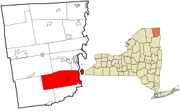
 Location in Clinton County and the state of New York. |
|
| Coordinates: 44°35′9″N 73°31′13″W / 44.58583°N 73.52028°WCoordinates: 44°35′9″N 73°31′13″W / 44.58583°N 73.52028°W | |
| Country | United States |
| State | New York |
| County | Clinton |
| Government | |
| • Type | Town Council |
| • Town Supervisor | Peter G. Glushko (R) |
| • Town Council |
Members' List
|
| Area | |
| • Total | 92.4 sq mi (239.3 km2) |
| • Land | 78.9 sq mi (204.3 km2) |
| • Water | 13.5 sq mi (34.9 km2) |
| Elevation | 436 ft (133 m) |
| Population (2010) | |
| • Total | 6,998 |
| • Density | 89/sq mi (34.3/km2) |
| Time zone | Eastern (EST) (UTC-5) |
| • Summer (DST) | EDT (UTC-4) |
| ZIP code | 12972 |
| Area code(s) | 518 |
| FIPS code | 36-57375 |
| GNIS feature ID | 0979358 |
| Website | www |
Peru is a town in Clinton County in the U.S. state of New York. The population was 6,998 at the 2010 census. The town was named Peru because the mountainous nature of its western reaches suggested that country. Peru is in the southeastern part of Clinton County, south of Plattsburgh.
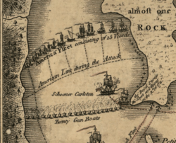
The area was first settled in 1772. The Battle of Valcour Island was fought in Lake Champlain in the eastern part of Peru in 1776.
Peru was formed from parts of the towns of Plattsburgh and Willsboro (the latter now in Essex County) in 1792. Part of Peru was returned to Willsboro in 1799. In 1838, part of the town was used to form the towns of Au Sable and Black Brook.
On April 20, 2002, around 6:50 am, a magnitude 5.2 earthquake was centered in the western part of Peru, 15 miles (24 km) southwest of Plattsburgh. The earthquake was felt as far north as Montreal, as far west as Cleveland, Ohio, as far south as Baltimore, Maryland, and throughout New England to the east. No injuries or deaths were reported, but moderate damage in the surrounding area was common, including partial road collapses, fallen chimneys, and broken windows.
According to the United States Census Bureau, the town of Peru has a total area of 92.4 square miles (239.3 km2), of which 78.9 square miles (204.3 km2) is land and 13.5 square miles (34.9 km2), or 14.60%, is water.
The eastern part of the town fronts on Lake Champlain, and the eastern town line, in the center of the lake, is the state border with Vermont. The Ausable River forms part of the south town line, and the Little Ausable River flows eastward through the south part of Peru.
...
Wikipedia
