Mpumalanga Province
| Mpumalanga | |||
|---|---|---|---|
| Province of South Africa | |||
|
|||
| Motto: Omnia labor vincit (Labour will conquer all) | |||
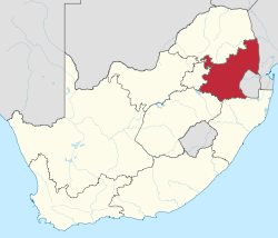
 Location of Mpumalanga in South Africa |
|||
| Country | South Africa | ||
| Established | 27 April 1994 | ||
| Capital | Nelspruit (Mbombela) | ||
| Districts | |||
| Government | |||
| • Type | Parliamentary system | ||
| • Premier | David Mabuza (ANC) | ||
| Area | |||
| • Total | 76,495 km2 (29,535 sq mi) | ||
| Area rank | 8th in South Africa | ||
| Highest elevation | 2,331 m (7,648 ft) | ||
| Population (2011) | |||
| • Total | 4,039,939 | ||
| • Estimate (2015) | 4,283,900 | ||
| • Rank | 6th in South Africa | ||
| • Density | 53/km2 (140/sq mi) | ||
| • Density rank | 3rd in South Africa | ||
| Population groups | |||
| • Black African | 90.7% | ||
| • White | 7.5% | ||
| • Coloured | 0.9% | ||
| • Indian or Asian | 0.7% | ||
| Languages | |||
| • Swati | 27.7% | ||
| • Zulu | 24.1% | ||
| • Tsonga | 10.4% | ||
| • Ndebele | 10.1% | ||
| • Northern Sotho | 9.3% | ||
| Time zone | SAST (UTC+2) | ||
| ISO 3166 code | ZA-MP | ||
| Website | www.mpumalanga.gov.za | ||
Mpumalanga ![]() i/əmˌpuːməˈlɑːŋɡə/ (name changed from Eastern Transvaal on 24 August 1995), is a province of South Africa. The name means "east", or literally "the place where the sun rises" in the Swazi, Xhosa, Ndebele and Zulu languages. Mpumalanga lies in eastern South Africa, bordering Swaziland and Mozambique. It constitutes 6.5% of South Africa's land area. It shares borders with the South African provinces of Limpopo to the north, Gauteng to the west, the Free State to the southwest, and KwaZulu-Natal to the south. The capital is Nelspruit. Before 1994, Mpumalanga was part of Transvaal Province.
i/əmˌpuːməˈlɑːŋɡə/ (name changed from Eastern Transvaal on 24 August 1995), is a province of South Africa. The name means "east", or literally "the place where the sun rises" in the Swazi, Xhosa, Ndebele and Zulu languages. Mpumalanga lies in eastern South Africa, bordering Swaziland and Mozambique. It constitutes 6.5% of South Africa's land area. It shares borders with the South African provinces of Limpopo to the north, Gauteng to the west, the Free State to the southwest, and KwaZulu-Natal to the south. The capital is Nelspruit. Before 1994, Mpumalanga was part of Transvaal Province.
The Drakensberg Escarpment divides Mpumalanga into a westerly half consisting mainly of high-altitude grassland called the Highveld and an eastern half situated in low-altitude subtropical Lowveld/Bushveld, mostly savanna habitat. The southern half of the Kruger National Park is in the latter region. The Drakensberg exceeds heights of 2000 m in most places, with this central region of Mpumalanga being very mountainous. These regions have alpine grasslands and small pockets of Afromontane forest. The Lowveld is relatively flat with interspersed rocky outcrops. The Lebombo Mountains form a low range in the far east, on the border with Mozambique.
...
Wikipedia


