KwaZulu-Natal
|
KwaZulu-Natal KwaZulu-Natali (Zulu) |
||
|---|---|---|
| Province of South Africa | ||
|
||
Motto:
|
||
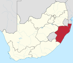
 Location of KwaZulu-Natal in South Africa |
||
| Country | South Africa | |
| Natalia Republic | 12 October 1839 | |
| Colony of Natal | 4 May 1843 | |
| Natal Province | 31 May 1910 | |
| KwaZulu-Natal | 27 April 1994 | |
| Capital | Pietermaritzburg | |
| Largest city | Durban | |
| Districts | ||
| Government | ||
| • Type | Parliamentary system | |
| • Premier | Willies Mchunu (ANC) | |
| Area | ||
| • Total | 94,361 km2 (36,433 sq mi) | |
| Area rank | 7th in South Africa | |
| Highest elevation | 3,451 m (11,322 ft) | |
| Lowest elevation | 0 m (0 ft) | |
| Population (2011) | ||
| • Total | 10,267,300 | |
| • Estimate (2015) | 10,919,100 | |
| • Rank | 2nd in South Africa | |
| • Density | 110/km2 (280/sq mi) | |
| • Density rank | 2nd in South Africa | |
| Population groups | ||
| • Black African | 86.8% | |
| • Indian or Asian | 7.4% | |
| • White | 4.2% | |
| • Coloured | 1.4% | |
| Languages | ||
| • Zulu | 77.8% | |
| • English | 13.2% | |
| • Xhosa | 3.4% | |
| • Afrikaans | 1.6% | |
| Time zone | SAST (UTC+2) | |
| ISO 3166 code | ZA-NL | |
| Website | www |
|
KwaZulu-Natal (/kwɑːˌzuːluː nəˈtɑːl/; also referred to as KZN and known as "the garden province") is a province of South Africa that was created in 1994 when the Zulu bantustan of KwaZulu ("Place of the Zulu" in Zulu) and Natal Province were merged. It is located in the southeast of the country, enjoying a long shoreline beside the Indian Ocean and sharing borders with three other provinces and the countries of Mozambique, Swaziland and Lesotho. Its capital is Pietermaritzburg and its largest city is Durban. It is the 2nd most populous province in South Africa, with slightly fewer residents than Gauteng.
During the 1830s and early 1840s, the northern part of what is now KwaZulu-Natal was occupied by the Zulu Kingdom while the southern part was, briefly, the Boer republic of Natalia before becoming, in 1843, the British Colony of Natal. KwaZulu remained independent until 1879.
...
Wikipedia

