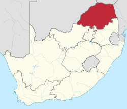
Limpopo
| Limpopo | ||
|---|---|---|
| Province of South Africa | ||
|
||
| Motto: Peace, Unity and Prosperity | ||
 Location of Limpopo in South Africa |
||
| Country | South Africa | |
| Established | 27 April 1994 | |
| Capital | Polokwane | |
| Districts | ||
| Government | ||
| • Type | Parliamentary system | |
| • Premier | Stanley Mathabatha (ANC) | |
| Area | ||
| • Total | 125,754 km2 (48,554 sq mi) | |
| Area rank | 5th in South Africa | |
| Highest elevation | 2,126 m (6,975 ft) | |
| Population (2011) | ||
| • Total | 5,404,868 | |
| • Estimate (2015) | 5,726,800 | |
| • Rank | 5th in South Africa | |
| • Density | 43/km2 (110/sq mi) | |
| • Density rank | 5th in South Africa | |
| Population groups | ||
| • Black African | 96.7% | |
| • White | 2.6% | |
| • Indian or Asian | 0.3% | |
| • Coloured | 0.3% | |
| Languages | ||
| • Northern Sotho | 52.9% | |
| • Tsonga | 17.0% | |
| • Venda | 16.7% | |
| • Afrikaans | 2.3% | |
| Time zone | SAST (UTC+2) | |
| ISO 3166 code | ZA-LP | |
| Website | www.limpopo.gov.za | |
Limpopo (UK: /lɪmˈpəʊpəʊ/) is the northernmost province of South Africa. It is named after the Limpopo River, which forms the province's western and northern borders. The name "Limpopo" has its etymological origin in the Northern Sotho language word diphororo tša meetse, meaning "strong gushing waterfalls". The capital is Polokwane, formerly called Pietersburg.
The province was formed from the northern region of Transvaal Province in 1994, and was initially named Northern Transvaal. The following year, it was renamed Northern Province, which remained the name until 2003, when it was formally changed to Limpopo after deliberation by the provincial government and amendment of the South African Constitution. An alternate name considered for the province was Mapungubwe, the area where its most ancient gold-using civilization had been discovered a few years earlier.
Limpopo has the highest level of poverty of any South African province, with 78.9% of the population living below the national poverty line. In 2011, 74.4% of local dwellings were located in a tribal or traditional area, compared to a national average of 27.1%. The Northern Sotho language is spoken by more than half of Limpopo's population.
Limpopo Province shares international borders with districts and provinces of three countries: Botswana's Central and Kgatleng districts to the west and northwest respectively, Zimbabwe's Matabeleland South and Masvingo provinces to the north and northeast respectively, and Mozambique's Gaza Province to the east. Limpopo is the link between South Africa and countries further afield in sub-Saharan Africa. On its southern edge, from east to west, it shares borders with the South African provinces of Mpumalanga, Gauteng, and North West. Its border with Gauteng includes that province's Johannesburg-Pretoria axis, the most industrialized metropole on the continent. The province is at the centre of regional, national, and international developing markets.
...
Wikipedia

