Jawa Timur
|
East Java Jawa Timur Jåwå Wétan ꧋ꦗꦮꦮꦺꦠꦤ꧀ |
|||||||||
|---|---|---|---|---|---|---|---|---|---|
| Province | |||||||||
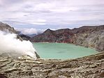
Clockwise, from top left : Bromo Tengger Semeru National Park, Mount Arjuno-Welirang, Lake Sarangan, Bali Strait, Klayar Beach in Pacitan, The sulfuric lake of Kawah Ijen Mountain's cauldron, Savanna in Baluran National Park
|
|||||||||
|
|||||||||
| Motto: Jer Basuki Mawa Béya (Javanese) (meaning: Sacrifices are needed to gain a greatness) |
|||||||||
 Location of East Java in Indonesia |
|||||||||
| Coordinates: 7°16′S 112°45′E / 7.267°S 112.750°ECoordinates: 7°16′S 112°45′E / 7.267°S 112.750°E | |||||||||
| Country |
|
||||||||
| Established | February 25, 1950 | ||||||||
| Capital |
|
||||||||
| Government | |||||||||
| • Body | East Java Regional Government | ||||||||
| • Governor | Soekarwo | ||||||||
| • Vice Governor | Saifullah Yusuf | ||||||||
| Area | |||||||||
| • Total | 47,799.75 km2 (18,455.59 sq mi) | ||||||||
| Area rank | 14th | ||||||||
| Highest elevation | 3,676 m (12,060 ft) | ||||||||
| Population (2014) | |||||||||
| • Total | 38,529,481 | ||||||||
| • Rank | 2nd | ||||||||
| • Density | 810/km2 (2,100/sq mi) | ||||||||
| Demographics | |||||||||
| • Ethnic groups | Javanese (80%), Madurese (18%), Chinese (2%) | ||||||||
| • Religion | Islam (96.36%), Christianity (2.4%), Buddhism (0.6%), Hinduism (0.5%), Confucianism (0.1%), Kejawen also practised | ||||||||
| • Languages | Indonesian (official), Javanese languages (Arekan & Osing), Madurese (regional) | ||||||||
| Time zone | Indonesia Western Time (UTC+7) | ||||||||
| Postcodes | 60xxx, 61xxx, 62xxx | ||||||||
| Area codes | (62)3xx | ||||||||
| ISO 3166 code | ID-JI | ||||||||
| Vehicle sign | AE, AG, L, M, N, P, S, W | ||||||||
| GRP per capita | US$ 3,361 | ||||||||
| GRP rank | 9th | ||||||||
| HDI |
|
||||||||
| HDI rank | 17th | ||||||||
| Largest city by area | Surabaya - 350.54 square kilometres (135.34 sq mi) | ||||||||
| Largest city by population | Surabaya - (2,765,487- 2010) | ||||||||
| Largest regency by area | Banyuwangi Regency - 5,782.40 square kilometres (2,232.60 sq mi) | ||||||||
| Largest regency by population | Malang Regency - (2,446,218 - 2010) | ||||||||
| Website | Government official site | ||||||||
East Java (Indonesian: Jawa Timur, abbreviated as Jatim, Javanese: Jåwå Wétan) is a province of Indonesia. Located in eastern Java, it includes the islands of Madura, which is connected to Java by the longest bridge in Indonesia, Suramadu Bridge, as well as the Kangean and Masalembu archipelagos located further east and north, respectively. Its capital is Surabaya, the second largest city in Indonesia and a major industrial center. Banyuwangi is the largest regency in East java and also in Java Island
It covers an area of 47,800 km2, According to the 2010 Census estimates, there were 37,476,757 people residing in the East Java, making it Indonesia's second-most-populous province; the latest official estimates (for January 2014) is 38,529,481.
It has a land border only with the province of Central Java to the west; Java Sea and Indian Ocean border its northern and southern coasts, respectively, while the narrow Bali Strait to the east separates Java from Bali.
The Dinoyo inscriptions found near the city of Malang is the oldest written sources in East Java, written in the year AD 760. This inscription tells many political and cultural events in the Kingdom of Dinoyo. Malang name itself is estimated to come from the name of a sacred building called Malangkuseswara. This name is contained in at least one inscription, namely, the Mantyasih inscriptions written in AD 907.
...
Wikipedia


