Bromo Tengger Semeru National Park
| Bromo Tengger Semeru National Park | |
|---|---|
| Taman Nasional Bromo Tengger Semeru | |
|
IUCN category II (national park)
|
|

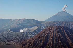
Clockwise from lower left: the Hindu temple Poten, the steaming crater of Mount Bromo, erupting Mount Semeru, stately Mount Batok.
|
|
|
Location in Java
|
|
| Location | East Java, Indonesia |
| Nearest city | Malang |
| Coordinates | 8°1′S 112°55′E / 8.017°S 112.917°ECoordinates: 8°1′S 112°55′E / 8.017°S 112.917°E |
| Area | 50,276 hectares (124,230 acres; 502.76 km2) |
| Established | October 14, 1982 |
| Visitors | 61,704 (in 2007) |
| Governing body | Ministry of Environment and Forestry |
| Website | bromotenggersemeru |
Bromo Tengger Semeru National Park is located in East Java, Indonesia, to the east of Malang and to the southeast of Surabaya, the capital of East Java. It is the only conservation area in Indonesia that has a sand sea, the Tengger Sand Sea (Indonesian: Laut Pasir Tengger), across which is the caldera of an ancient volcano (Tengger) from which four new volcanic cones have emerged. This unique feature covers a total area of 5,250 hectares at an altitude of about 2,100 m. The massif also contains the highest mountain in Java,Mount Semeru (3,676 m), four lakes and 50 rivers.
The Tengger Sand Sea has been protected since 1919. The Bromo Tengger Semeru National Park was declared a national park in 1982.
The volcanic complex of Tengger forms a condition where a new caldera of volcano forms inside a larger and more ancient caldera. There are five volcanoes inside the Tengger Caldera: Mount Bromo (2,329 m), Mount Batok (2,470 m), Mount Kursi (2,581 m), Mount Watangan (2,661 m), and Mount Widodaren (2,650 m). Mount Batok is the only peak that is no longer active, and is covered in casuarina (Indonesian: cemara) trees. Mount Widodaren, located beside Mount Batok, contains the cave Widodaren, which is considered sacred by local people.
The five volcanoes within the caldera are surrounded by a vast area of sand called the Tengger Sand Sea, which in turn is surrounded by a steep crater wall of the larger Tengger Caldera with height differences of about 200–600 meters. Other mountains around the Tengger caldera are: Mount Pananjakan (2,770 m) Mount Cemorolawang (2,227 m), Mount Lingker (2,278 m), Mount Pundak Lembu (2,635 m), Mount Jantur (2,705 m), Mount Ider-ider (2,527 m) and Mount Mungal (2,480 m). The peak of Mount Pananjakan is the most popular place to watch the entire volcanic complex of Tengger.
Further south in the national park, there is another volcanic complex called the Semeru Group or Jambangan Group. This area contains the highest peak of Java, Mount Semeru (3,676 m). Other mountains within this area are Mount Lanang (2,313 m), Mount Ayek-ayek (2,819 m), Mount Pangonan Cilik (2,833 m), Mount Keduwung (2,334 m), Mount Jambangan (3,020 m), Mount Gentong (1,951 m), Mount Kepolo (3,035 m), and Mount Malang (2,401 m). The Semeru forest area has many rivers that are former lava lines from Mount Semeru. The Semeru group is considered to be very productive, producing volcanic matters such as lava, volcanic ash, and hot cloud and spreading it to the surrounding area. The lower area is surrounded with fertile rice fields.
...
Wikipedia

