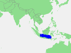
Java Sea
| Java Sea | |
|---|---|

Location of the Java Sea
|
|
| Location | Sunda Shelf |
| Coordinates | 5°S 110°E / 5°S 110°ECoordinates: 5°S 110°E / 5°S 110°E |
| Type | Sea |
| Basin countries | Indonesia |
| Max. length | 1,600 km (990 mi) |
| Max. width | 380 km (240 mi) |
| Surface area | 320,000 km2 (120,000 sq mi) |
| Average depth | 46 m (151 ft) |
The Java Sea (Indonesian: Laut Jawa) is a large shallow sea on the Sunda Shelf. It lies between the Indonesian islands of Borneo to the north, Java to the south, Sumatra to the west, and Sulawesi to the east. Karimata Strait to its northwest links it to the South China Sea.
The Java Sea covers the southern section of the 1,790,000 km2 (690,000 sq mi) Sunda Shelf. A shallow sea, it has a mean depth of 46 m (151 ft). It measures about 1,600 km (990 mi) east-west by 380 km (240 mi) north-south and occupies a total surface area of 320,000 km2 (120,000 sq mi).
It formed as sea levels rose at the end of the last ice age. The almost uniform flatness of the sea bottom and the presence of drainage channels (traceable to the mouths of island rivers) indicate that the Sunda Shelf was once a stable, dry, low-relief land area (peneplain) above which were left standing a few monadnocks (granite hills that by virtue of their resistance to erosion form the present islands).
The International Hydrographic Organization (IHO) defines the Java Sea as being one of the waters of the East Indian Archipelago. The IHO defines its limits as follows:
On the North. By the Southern limit of the South China Sea [Lucipara Point (3°14′S 106°05′E / 3.233°S 106.083°E) thence to Tanjong Nanka, the Southwest extremity of Banka Island, through this island to Tanjong Berikat the Eastern point (2°34′S 106°51′E / 2.567°S 106.850°E), on to Tanjong Djemang (2°36′S 107°37′E / 2.600°S 107.617°E) in Billiton, along the North coast of this island to Tanjong Boeroeng Mandi (2°46′S 108°16′E / 2.767°S 108.267°E) and thence a line to Tanjong Sambar (3°00′S 110°19′E / 3.000°S 110.317°E) the Southwest extreme of Borneo], the South coast of Borneo and the Southern limit of Makassar Strait [By a line from the Southwestern extreme of Celebes (5°37′S 119°27′E / 5.617°S 119.450°E), through the Southern point of Tana Keke, to the Southern extreme of Laoet (4°06′S 116°06′E / 4.100°S 116.100°E) thence up the West coast of that island to Tanjong Kiwi and thence across to Tanjong Petang, Borneo (3°37′S 115°57′E / 3.617°S 115.950°E) at the Southern end of Laoet Strait].
...
Wikipedia
