Baluran National Park
| Baluran National Park | |
|---|---|
|
IUCN category II (national park)
|
|

Wild deer near Bama Point, Baluran
|
|
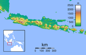
| Location in Java | |
| Location | Situbondo Regency, East Java, Indonesia |
| Coordinates | 7°50′S 114°22′E / 7.833°S 114.367°ECoordinates: 7°50′S 114°22′E / 7.833°S 114.367°E |
| Area | 250 km2 (97 sq mi) |
| Established | 1980 |
| Visitors | 10,192 (in 2007) |
| Governing body | Ministry of Forestry |
Baluran National Park is located in Situbondo Regency, East Java, Indonesia. It has a relatively dry climate and mainly consists of savanna (40%), as well as lowland forests, mangrove forests and hills, with Mount Baluran (1,247m) as its highest peak.
Baluran National Park is situated at the north-eastern extremity of Java, close to the islands of Bali and Madura. The park is bordered by the Madura Strait to the north, the Bali Strait to the east, the river Bajulmati (Wonorejo village) to the west and the river Klokoran (Sumberanyar village) to the south. The park is a rough circle, with the extinct volcano, Baluran, at its centre. Its total area is 25,000 ha. It consists of five zones: the Main Zone (12,000 ha), the Wilderness Zone (5,537 ha, comprising 1,063 ha water and 4,574 ha land), the Intensive Utilization Zone (800 ha), the Specific Utilization Zone (5,780 ha) and the Rehabilitation Zone (783 ha).
There have been 444 species of plant recorded in the park, including some endangered plant species, such as: Ziziphus rotundifolia, Tamarindus indica, Dioscorea hispida, Aleurites moluccanus and Corypha utan.
The park is host to 26 species of mammals, including the endangered banteng, Sumatran dhole, Indian muntjac, Java mouse-deer, fishing cat, Javan leopard and Javan lutung. The banteng population decreased from 338 in 1996 to just 26 in 2012.
...
Wikipedia

