Interstate 20 (South Carolina)
| Interstate 20 | ||||
|---|---|---|---|---|
| J. Strom Thurmond Freeway | ||||
 |
||||
| Route information | ||||
| Maintained by SCDOT | ||||
| Length: | 141.51 mi (227.74 km) | |||
| Existed: | 1964 – present | |||
| Major junctions | ||||
| West end: |
|
|||
|
|
||||
| East end: |
|
|||
| Location | ||||
| Counties: | Aiken, Lexington, Richland, Kershaw, Lee, Darlington, Florence | |||
| Highway system | ||||
|
||||
| Interstate 20 Business | |
|---|---|
| Location: | Florence, South Carolina |
| Length: | 2.0 mi (3.2 km) |
| Existed: | 1970–present |
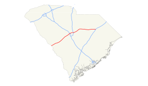
Interstate 20 (I-20) is a major thoroughfare cutting across the state of South Carolina, linking the state with important transportation and business hubs to the north, west and south, including Atlanta, Georgia, Charlotte, North Carolina (via I-77), Savannah, Georgia (via I-95) and Washington, D.C. (via I-95).
I-20 enters the Palmetto State after crossing the Savannah River from Augusta, Georgia. Known as the J. Strom Thurmond Freeway, the highway heads northeastward, bypassing Aiken and Lexington before reaching the state capital of Columbia. It was constructed in various stages beginning in late 1963, with the final section between SC-340 and the Business Spur opening in August 1975.
At Columbia, I-20 crosses the Saluda and Broad rivers and travels through the northern part of the city and turns eastward, bypassing Fort Jackson and Camden before reaching Florence. It is at Florence where I-20 sees its eastern terminus at I-95. However, for about 2 miles (3.2 km), the highway continues to downtown Florence as Business Spur 20.
...
Wikipedia

